Parking and Sport
-
-
Skills training on Wednesday and AGM updates
- Wellington Orienteering Association
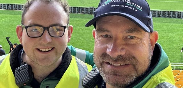
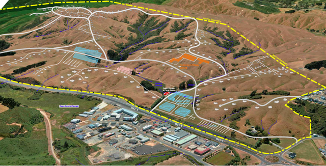
- Skills training on Wednesday and AGM updates Last-ditch skills training for the year on Kaukau this Wednesday ͏ ͏ ͏ ͏ ͏ ͏ ͏ ͏ ͏ ͏ ͏ ͏ ͏ ͏ ͏ ͏ ͏ ͏ ͏ ͏ ͏ ͏ ͏ ͏ ͏ ͏ ͏ ͏ ͏ ͏ ͏ ͏ ͏ ͏ ͏ ͏ ͏ ͏ ͏ ͏ ͏ ͏ ͏ ͏ ͏ ͏ ͏ ͏ ͏ ͏ ͏ ͏ ͏ ͏ ͏ ͏ ͏ ͏ ͏ ͏ ͏ ͏ ͏ ͏ ͏ ͏ ͏ ͏ ͏ ͏ ͏ ͏ ͏ ͏ ͏ ͏ ͏ ͏ ͏ ͏ ͏ ͏ ͏ ͏ ͏ ͏ ͏ ͏ ͏ ͏ ͏ ͏ ͏ ͏ ͏ ͏ ͏ ͏ ͏ ͏ ͏ ͏ ͏ ͏ ͏ ͏ ͏ ͏ ͏ ͏ ͏ ͏ ͏ ͏ ͏ ͏ ͏ ͏ ͏ ͏ ͏ ͏ ͏ ͏ ͏ ͏ ͏ ͏ ͏ ͏ ͏ ͏ ͏ ͏ ͏ ͏ ͏ ͏ ͏ ͏ ͏ ͏ ͏ ͏ ͏ ͏ ͏ ͏ ͏ ͏ ͏ ͏ ͏ ͏ ͏ ͏ ͏ ͏ ͏ ͏ ͏ ͏ ͏ ͏ ͏ ͏ ͏ ͏ ͏ ͏ ͏ ͏ ͏ ͏ ͏ ͏ ͏ ͏ ͏ ͏ ͏ ͏ ͏ ͏ ͏ ͏ ͏ ͏ ͏ ͏ ͏ ͏ ͏ ͏ ͏ ͏ ͏ ͏ ͏ ͏ ͏ ͏ ͏ ͏ ͏ ͏ ͏ ͏ ͏ ͏ ͏ ͏ ͏ ͏ ͏ ͏ ͏ ͏ ͏ ͏ ͏ ͏ ͏ ͏ ͏ ͏ ͏ ͏ ͏ ͏ ͏ ͏ ͏ ͏ ͏ ͏ ͏ ͏ ͏ ͏ ͏ ͏ ͏ ͏ ͏ ͏ ͏ ͏ ͏ ͏ ͏ ͏ ͏ ͏ ͏ ͏ ͏ ͏ ͏ ͏ ͏ ͏ ͏ ͏ ͏ ͏ ͏ ͏ ͏ ͏ ͏ ͏ ͏ ͏ ͏ ͏ ͏ ͏ ͏ ͏ ͏ ͏ ͏ ͏ ͏ ͏ ͏ ͏ ͏ ͏ ͏ ͏ ͏ ͏ ͏ ͏ ͏ ͏ ͏ ͏ ͏ ͏ ͏ ͏ ͏ ͏ ͏ ͏ ͏ ͏ ͏ ͏ ͏ ͏ ͏ ͏ ͏ ͏ ͏ ͏ View this email in your browser Training this Wednesday and AGM updates Meri Kirihimete <>! After the successful and fun afterwork series—and before you check out for the holidays—we are putting on a training session focussing on compass skills. The training will occur on Kaukau, at 6—7pm Wednesday, 17 December. Our session is aimed at those wanting to learn new skills and techniques, or those with more experience who want to practise their techniques, and is suitable for every ability (kids and adults welcome!). Bring your compass and clothes suitable for the weather, as it can be exposed on the tops. No dogs are allowed on the farmland. The session will be coached by Rachel and Yvette Baker, so please email Rachel at rachel.rosara.baker@gmail.com if you have any questions, or need to borrow a compass. On-street parking is available at our meeting point at the end of McLintock Street, accessed from Truscott Avenue. See the map. Key takeouts from the AGM If you missed the AGM, don’t worry. Here are some of the key takeouts. “This year has been one of growth, development, and community spirit as we continue to promote and enhance the sport of orienteering across the Wellington region.”—Beverley Holder, President You can read more about our club achievements—events, training, mapping and more—in Beverley’s report below. There will be no change to subscription fees for 2026. President’s report Committee and working groups As elected committee for 2026 is: Beverley Holder (President) Gerald Crawford (Treasurer) Lachlan McKenzie Jake Hanson Paul Teasdale-Spittle The committee will be supported by working groups to fulfil the club’s many functions. Working groups have been proposed but not confirmed, and are not necessarily permanent—they may be based around time-bound projects. We’d love to hear from you about which groups you think might be useful, and how you may like to contribute. Read the discussion paper and send your thoughts to Lachlan at secretary@wellingtonorienteering.org.nz Discussion paper Awards Congratulations to our award recipients this year. The Endeavour Cup is awarded for development and performance, and the Fortune Cup is awarded for outstanding service to the club. Endeavour Cup Rachel Baker received this year’s Endeavour Cup for her outstanding performances including as part of the New Zealand team at this year’s Junior World Orienteering Championships in Italy. Other nominees were Morag McLellan and Jake McLellan. Fortune Cup Alan Horn received the Fortune Cup. Alan unfailingly provides outstanding support for events, gear, and controlling and planning. Other nominees were Paul Teesdale-Spittle, Helen Hughes, Lachlan McKenzie and Will Vale. Members’ League We will be trialling a members’ league in 2026—a way to introduce some fun competition into events where scores are based on comparative performance, rather than absolute as per race time. Details are being worked through but generally will look like this: For members age 16 or over who run a Red-level course CSWs and OYs will be ‘counting events’ Scores will be allocated based on the formula “Average km rate * (age and gender weighting)” Overall winner: If there are 10 ‘counting events’, we will take your top 6 scores. Coming events Orienteering Wellington’s coming events can be found on our Events page. You can also toggle the calendar to show Orienteering Hutt Valley’s events. Sprint, Whitireia Campus – Wednesday 11 February Sprint, Victoria University – Wednesday 25 February Sprint, Masey University – Wednesday 11 March CSW, Tikara, Churton Park – Sunday 23 March For all events, visit Orienteering New Zealand. About us We welcome all who live around Te Whanganui-a-Tara to discover our special region through orienteering. Be part of our community at Orienteering Wellington. Copyright (C) 2025 Orienteering Wellington. All rights reserved. Our mailing address is: Want to change how you receive these emails? You can update your preferences or unsubscribe
- Accepted from Wellington Orienteering Association feed 2024 by feedreader
- Tagged as:
- hutt-valley
- dogs
- orienteering
- parking
Lower Hutt, Wellington, New Zealand (OpenStreetMap)
-
-
-
August 2025 - A blizzard of activity
- Wellington Orienteering Association
- August 2025 - A blizzard of activity ͏ ͏ ͏ ͏ ͏ ͏ ͏ ͏ ͏ ͏ ͏ ͏ ͏ ͏ ͏ ͏ ͏ ͏ ͏ ͏ ͏ ͏ ͏ ͏ ͏ ͏ ͏ ͏ ͏ ͏ ͏ ͏ ͏ ͏ ͏ ͏ ͏ ͏ ͏ ͏ ͏ ͏ ͏ ͏ ͏ ͏ ͏ ͏ ͏ ͏ ͏ ͏ ͏ ͏ ͏ ͏ ͏ ͏ ͏ ͏ ͏ ͏ ͏ ͏ ͏ ͏ ͏ ͏ ͏ ͏ ͏ ͏ ͏ ͏ ͏ ͏ ͏ ͏ ͏ ͏ ͏ ͏ ͏ ͏ ͏ ͏ ͏ ͏ ͏ ͏ ͏ ͏ ͏ ͏ ͏ ͏ ͏ ͏ ͏ ͏ ͏ ͏ ͏ ͏ ͏ ͏ ͏ ͏ ͏ ͏ ͏ ͏ ͏ ͏ ͏ ͏ ͏ ͏ ͏ ͏ ͏ ͏ ͏ ͏ ͏ ͏ ͏ ͏ ͏ ͏ ͏ ͏ ͏ ͏ ͏ ͏ ͏ ͏ ͏ ͏ ͏ ͏ ͏ ͏ ͏ ͏ ͏ ͏ ͏ ͏ ͏ ͏ ͏ ͏ ͏ ͏ ͏ ͏ ͏ ͏ ͏ ͏ ͏ ͏ ͏ ͏ ͏ ͏ ͏ ͏ ͏ ͏ ͏ ͏ ͏ ͏ ͏ ͏ ͏ ͏ ͏ ͏ ͏ ͏ ͏ ͏ ͏ ͏ ͏ ͏ ͏ ͏ ͏ ͏ ͏ ͏ ͏ ͏ ͏ ͏ ͏ ͏ ͏ ͏ ͏ ͏ ͏ ͏ ͏ ͏ ͏ ͏ ͏ ͏ ͏ ͏ ͏ ͏ ͏ ͏ ͏ ͏ ͏ ͏ ͏ ͏ ͏ ͏ ͏ ͏ ͏ ͏ ͏ ͏ ͏ ͏ ͏ ͏ ͏ ͏ ͏ ͏ ͏ ͏ ͏ ͏ ͏ ͏ ͏ ͏ ͏ ͏ ͏ ͏ ͏ ͏ ͏ ͏ ͏ ͏ ͏ ͏ ͏ ͏ ͏ ͏ ͏ ͏ ͏ ͏ ͏ ͏ ͏ ͏ ͏ ͏ ͏ ͏ ͏ ͏ ͏ ͏ ͏ ͏ ͏ ͏ ͏ ͏ ͏ ͏ ͏ ͏ ͏ ͏ ͏ ͏ ͏ ͏ ͏ ͏ ͏ ͏ ͏ ͏ ͏ ͏ ͏ ͏ ͏ ͏ ͏ ͏ ͏ ͏ ͏ ͏ ͏ ͏ ͏ ͏ View this email in your browser August 2025 news Kia ora koutou There’s been a blizzard of activity this winter, including member successes and fantastic events like Hydrabad, Khandallah Score, Mill Creek, Baring Head, the Whitby night event and Matariki/Waikawa weekend special. Our practical training at Karori Park saw a fantastic turnout of some 50 new and developing orienteers, with a number of members volunteering their time to coach groups around a set course. If you missed these great events and have FOMO, you can check out the maps on the events and results page of our website. Our new Constitution was accepted by members at a Special General Meeting in June. This allows us to comply with the new Incorporated Societies Act 2022, enabling Orienteering Wellington to remain registered as an incorporated society. We hope this Constitution will serve us well, but it is new to our club. If there are things that you don’t feel are working in the best interests of the club then let the Committee know, so that we can bring these to members’ attention for consideration at Annual General Meetings. Beverley Holder President Participants ready themselves for the Whitby night courses. Major events on the horizon Pokapū Regional Championships are just around the corner at Labour Weekend (25 – 7 October), hosted by Red Kiwis. A sprint will be held in Palmerston North, while the long and middle events will be at Santoft forest. Entries open soon—don’t miss this orienteering bonanza! Tūāraki (Northern) Regional Champs (8 – 9 November) will be hosted by Orienteering Bay of Plenty andTaupō Orienteering Club. Events will be near Rotorua, on the Opepe and Lake Okataina maps. Entries are open. Find out more. Our Spring Classic will be on Sunday 23 November on a new map in Waikanae. The Classic is a longstanding endurance event, the course incorporating relay loops (which competitors run solo) followed by a longer conventional course. The M40 class incorporates the Wayne Cretney Memorial that commemorates Wayne, a Wairarapa orienteer who was tragically killed in an accident in 1988 at the age of 44. All Orienteering Wellington members are invited to our End‑of‑year social on Saturday 6 December! It’s a great chance to look back on and celebrate a busy year, swap stories, and agonise over “the run that got away”. More details coming soon. 50th‑Birthday celebrations: Orienteering Wellington turns 50 next year—our golden jubilee! That’s quite a milestone, and we’ll be marking the occasion with festivities in the middle of next year. Stay tuned! Young ‘uns, young guns! Younger Orienteering Wellington members shone in Europe. Rachel Baker was part New Zealand’s Junior World Orienteering Champs team in Trentino, Italy (26 June – 3 July). She placed 65 in the sprint, 21 in the long, and 39 in the middle, and was a member of the sprint and forest relay teams that placed 42 and 15 respectively. Rachel went on to the World Orienteering Champs in Kuopio, Finland (8 – 12 July), where she brought the Women’s relay team into eighteenth position after the first leg. She also placed 38 in the middle-distance event. Jake McLellan smashed his way to seventh place at the Junior World Orienteering Champs sprint, 28 on the long and 75 for the middle event. The men’s relay team of which he was part placed 15. We’re super proud of Rachel and Jake, who performed outstandingly. Another of our young stars, Morag McLellan, was selected to represent New Zealand at the European Youth Orienteering Champs Brno, Czechia (17 – 20 July) but sadly unable to attend. And a correction… Our May newsletter featured Jake McLellan’s massive (non-orienteering) achievement of winning the Tararua Mountain Race. His win was significantly more epic than stated – a chip time of 5:07:12 (some two hours less than we gave him credit for!). Our apologies, Jake. Quiz: Which map? This may not have been your course, but do you recognise this recent map? The answer is at the bottom. Explore our permanent courses We’ve been checking our two permanent courses – on Wellington’s Waterfront and Matairangi (Mount Victoria) – are in order and that maps and plaques are current. These central city DIY courses are perfect for training, casual outings, or introducing others to orienteering. Please explore them and share them with your friends! You can download maps and instructions for permanent courses on our website. Explore permanent courses Nationals at Easter 2026 – Pack your bags for the Wairarapa At Easter 2026 (3-6 April), Orienteering Wellington is leading the charge to host the NZ Orienteering Championships (Nationals), with support from Red Kiwis, Orienteering Hutt Valley and Orienteering Wairarapa. Events will be in the Wairarapa and embargoed areas have been published on the ONZ website: · Sprint: Rathkeale College, Masterton · Middle: Rewanui Forest Park, Blairlogie (east of Masterton) · Long: Coonoor, east of Pahiatua · Relay: Riverside Farm, northwest of Masterton Nationals 2026 Nationals will likely attract more than 500 orienteers from around New Zealand and promises to be a standout event—please help make it legendary, both as a competitor and on the volunteer squad. Speaking of which….. You are key to our events! Your help at events makes all the difference—whether it’s on the computer, starts, registration, control collection, set-up, pack-down, parking or something else, we need hands on deck. Helping is a great way to meet others and don’t worry if you haven’t done a job before—we’ll show you the ropes. You don’t have to be a member to help either, and all volunteers enjoy a free run at that event. We are always looking for people who are interested in planning or controlling events. If this sounds like you then get in touch or rock on up to the desk at the next event. If you haven’t planned an event before then we’ll make sure you’re paired with someone who can help. The key thing is to allow plenty of time to realise your best possible courses. We’ve also published some basic resources specific to Orienteering Wellington events, which are a “must read” for all planners and controllers. Quiz answer The map shows part of the yellow course on the Waikawa map. Participants line up to start Waikawa. Coming events Orienteering Wellington’s coming events can be found on our Events page. You can also toggle the calendar to show Orienteering Hutt Valley’s events. Sunday 17 August – Score event, Kaitoke Monday 18 August – Mapper training, Lower Hutt Sunday 31 August – Score event, Mount Albert Sunday 7 September – Newlands Wednesday 10 September – Afterwork Rogaine, Brooklyn Wednesday 8 October – Afterwork Rogaine, Ōtari Sunday 12 October – OY, Waitārere Sunday 12 October – Training, Hydrabad map, Waitārere … For all events, visit Orienteering New Zealand About us We welcome all who live around Te Whanganui-a-Tara to discover our special region through orienteering. Be part of our community at Orienteering Wellington Copyright (C) 2025 Orienteering Wellington. All rights reserved. Our mailing address is: Want to change how you receive these emails? You can update your preferences or unsubscribe
- Accepted from Wellington Orienteering Association feed 2024 by feedreader
- Tagged as:
- khandallah
- waikanae
- parking
- wairarapa
- mount-victoria
- waterfront
- newlands
- lower-hutt
- orienteering
- brooklyn
- karori
Lower Hutt, Lower Hutt City, Wellington, 5010, New Zealand (OpenStreetMap)
-
-
-
Shaw Baton Relay – POSTPONED
- Hutt Valley Harriers
- Unfortunately, the weather conditions over the past couple of days have caused postponement of Shaw Baton Relay this weekend. The ground is too wet for car parking, etc. Come to the club rooms for a run tomorrow, it will help…
- Accepted from HVH news by feedreader
- Tagged as:
- parking
-
-
-
Plimmerton Farm: getting greenfields right
- Talk Wellington
- If we’re hellbent on doing more residential development in greenfields, what does “decent” look like in Plimmerton, hilly land near an existing suburb – like most of our region’s greenfields? This post is basically a guide for anyone who cares about Plimmerton, good urban development, or healthy wetlands, streams and coast, but is time-poor and can’t face going through the truckloads of documents they’ve stuck up without any specific meta-guidance (some FAQ are here). Hopefully this will help you pop in a submission! PCC’s “information” pages they suggest you use for submitting. Every one of these is a large PDF document, 90% written in technical language… aargh! The background: what where and how For those who don’t know, Plimmerton Farm’s a big proposed subdivision of hilly farmland draining into the significant Taupō Wetland and to Plimmerton Beach, just over the train line and highway from Plimmerton village (original Ngāti Toa name: Taupō). It’s going through a Streamlined Planning Process, a pre-COVID government scheme for accelerating development. The key step is the requisite change of the land’s zoning in the Porirua District Plan (“rural” zone to “residential” and other “urban” zones) that sets out what kind of stuff can then be built, where. It’s mostly streamlined because there’s just one shot for the public to have input on the plan change. One shot. Why submit? I was born and raised in Plimmerton, live here now, and intend to for the rest of my days. I’d love to see it grow, well. I would love Plimmerton to get more wallets, more hearts and minds, more faces (more diverse ones too!). But not with more traffic, and pointless damage to our environment. Right now, the proposal has some serious flaws which need sorting. I say Sorting because the changes won’t make it crazy innovative, just good enough for a development in the spot it is, being kicked off in 2020. Time matters too: there’a a bunch of good things happening imminently (and some bad Porirua trends that need to be reversed). I cover these in Get it right, below. It’s worth submitting because given the situation, a 1990s-grade development just won’t cut it. So what about Plimmerton Farm needs to change? It boils down to two themes: dial down the driveability and dial up the liveabilitymake Local the logical and easy choice for daily needs I’ll outline what needs to change in each. NOTE: There’s a third – don’t stuff the wetlands and streams. This is really important as Taupō Wetland is regionally significant, and all our streams and harbours have suffered from frankly shameful mismanagement of sediment from earthworks-heavy subdivisions like Aotea and Duck Creek, and from the earthworks-a-rama of Transmission Gully. Friends of Taupo Swamp have an excellent submission guide for you – add in some of their suggested bits to your submission. I: Dial down the driveability, dial up the liveability There aren’t many truly black-and-white things in life, but there’s one for towns: If a street is nice to drive in, it’ll be a crappy place to do anything else in (walk / eat / hang out / have a conversation / play / scoot or cycle / shop / have a pint). If it’s nice to do anything else in, it’ll be a crappy place to drive in. Mostly this is because of the nature of the automobile: big solid things that smash into our soft bodies if someone makes a mistake (75% odds of death if that’s at 50km/hour, 10% odds of death if at 30km/hour) big objects that need lots of space for manoeuvering and especially parking – which offstreet can be crazy expensive and push up the cost of a home, and onstreet hoover up valuable public space. big solid things driven by us real humans (for a while at least) who respond to the environment but also get distracted, and generally aren’t good at wielding these big solid things safely. The transport setup proposed for Plimmerton Farm makes for a much too driveable and poorly liveable place. 1. Narrow down all the roads. The current proposal’s roading setup has roads and streets that are too big, and there’s too much of them. Right sized roads for a liveable community The cross-sections for the roads include on-street parking and really wide lane widths. This is really gobsmacking for a consortium that talked a big talk about good practice. For all the reasons that Low Traffic Neighbourhoods are good, this is bad. (And it’s especially nuts when you realise that the excessively wide “arterial” roads (11 metres!) will need earthworked platforms built for them where they’re drawn running up the sharp ridges and across the tops of gullies. Expensive, damaging for the environment, and … what were they thinking?) So recommended changes: NARROW DOWN THE ROADS. Seriously. Design all the living-area streets and roads, and the centre, to be self-explaining for an operating traffic speed of 30km or less – that’s the speed where mistakes are rarely fatal. What does that look like? The designers will know and if they don’t they should be fired. Narrower crossing distances; chicanes (great way to incorporate green infrastructure and trees and seating!); narrowed sight-lines (trees! sculpture!) so no-one driving feels inclined to zoom. Reduced trafficked lanes (rori iti on the larger roads!), with properly wide and friendly footpaths. Threshold treatments, humps, modal filters, all the things we know very well are the natural ways to slow us down when driving, and make streets nicer for people. The beauty of all this “restriction” on driving is how much it frees us up for making everything else appealing. Streets become hospitable for kids to walk, scoot, bike to school safely, using the road not the footpath. Older people and those with impairments can walk and wheelchair safely. Teens coming home from town of an evening can scoot or bike home, safely. Popping down to the shops or for a coffee or to the train becomes a pleasure to do on foot, or on a scooter or bike. And you’re moving in a legitimate way – seeing and being seen, not stuck off in the bush on a “recreational” track like what they’ve described. The ordinary streets and roads are walkable, bikeable, scootable, mobility-scootable, and perfectly driveable, equally safe and useable in all weathers and anytime of day or night. Used to be a big, fast road. Now, kids bike to school and old people can chill out on it. (Mark Kerrison) (And in case you’re worried about firetrucks / rubbish trucks / buses, recall that on even Wellington City’s far more winding, narrower hilly streets everyone gets their rubbish collected and fires fought just fine. On public transport, smaller buses, like those that community transport operators use, are the way of the future for less densely-populated areas like this). Don’t build the through and loop roads. You don’t need signs like this when the only people who bother to drive in are those who live there, or who are visiting friends, because you just have to drive out again the way you came. When it’s the place you live, you’re invested in not being a dick far more than if you’re just out for a drive – or worse, out for a bit of a boyrace hoon on a massive loop route through a whole place. So just don’t build those big connector roads that enable people to drive easily from one residential area to the next, especially the ones up in the hilltops (section C) that just say “come for a hoon!” Instead, connect the living spaces heavily with bikeable, walkable, scootable, disability-friendly streets and lanes, and as much as possible, only one way in and out for cars from each living area. II: Make local logical and easy Plimmerton is a true village, with a great little centre (including a train station!) but Plimmerton Farm is ultimately a damn big area. The way to go is to enable people to get the basics of life – like school, groceries, a coffee – with a little local trip on foot, bike or scooter – it’s more of a bother to get in the car. Right now though, it needs two changes: 1. Provide for a second centre “Bumping into” spaces are known to be crucial to a feeling of neighbourhood, and in the (initial) absence of third places (worship places, community hall, sports club, cafe/pub, a supermarket is a vital social centre. Yet the north end of Plimmerton Farm is currently a deadzone for anything except residential. What things will probably look like under current layout. Like in Edwards Scissorhands without the interest of a castle. There’s no provision for a place to do your household groceries, so people will drive to Mana New World – more car trips – and less opportunity to bump into people who live nearby. (There’ll be no school in Plimmerton Farm for a while, because Ministry of Education isn’t allowed by the Education Act to build a school somewhere until there’s a certain population density of kids to fill it. A shitty Catch-22 for developments which is hopefully going to be fixed … sometime. Just another reason to make walking, biking and scooting really kid-friendly, as extra dropoff traffic for kids going to St Theresa’s, Plimmerton School, Paremata and Pukerua Bay schools will be a nightmare.) So they should provide for an additional centre in the north, including a groceries place of some kind. 2. Intensify within walking distance of Plimmerton proper. We should intensify properly, with lots of medium and even some high density (6 storeys of nicely laid-out density done well!) in the area that’s within a 5-minute walk of Plimmerton Village. The more people can live and work with access to all its many amenities, and its rail station (10 min to Porirua, 30 min to Wellington), the better. But there’s not enough density provided for there. Plimmerton Railway station: buzzing in 1916 and has only got bigger. (Photo: Pātaka Porirua Museum) So they should add another zone – E – of higher density in that 5-minute walking catchment of Plimmerton Village. What could it look like? A good example is 3333 Main, Vancouver . Submission tips On the site they ask you to fill in a Word or PDF form, saying which specific bit of the gazillion proposals you are talking about and the specific changes you want. This is a BS way to treat the vast majority of people submitting: normal non-professionals, just regular people who care about good development and liveable places. So just don’t worry about that. In those question 6 column boxes just put “Transport” and “Layout”. It’s the professional planners’ job to figure out specifically how to change a planning document. Just be specific enough that they know what you want to see. The text above is worth copying and pasting – it’ll be enough. And don’t forget the Friends of Taupo Swamp and Catchment advice is essential – definitely go read and use. That’s all you really need – just go submit! But if you’re keen to know more reasons why they should be doing this better, here’s some… Get it right, now Once this plan change is through, traditional developers like Gillies like to whack in all the infrastructure – hello, massive earthworks. And yet the place will take decades to fill with actual people – those hearts and minds and wallets. (Note even before COVID, Porirua’s growth rate was 0.1% per year. Yep, one tenth of one percent.) And extra pressure’s on to do this better because all these things are features of the next one to three years: the One Network Road Classification (sets the design specs for roads of different types) is being updated right now to be more people-friendly in the specs for roads in residential and centre areas, so designs like Plimmerton Farm’s will soon be Officially Bad Practice Sales and riding of e-bikes and e-scooters are going through the roof, continuing through and beyond COVID – this shows no signs of slowing, and prices are dropping. E-power flattens the hills of Plimmerton Farm and makes wheely active travel a breeze for the middle-class people who’ll be living here, if the streets and roads are hospitablePlimmerton Railway Station (on the most popular Wellington train line) is being upgraded to be a terminus station – i.e. better servicesThe Wellington Regional Growth Framework is setting a bunch of directions for councils on how to grow well, including well-known but often well-ignored issues like intensifying around public transport hubs Councils will soon be required to do to a bunch of a bunch of international good practice including get rid of many minimum parking requirements (in the news lately), and to upzone (enable intensification) of landuse in the walking catchment of public transport hubs. (5 min walk = approx 400 metres, 10 min = 800m).Bad trends we need to stop: Porirua’s really high car-dependency (we own cars a lot and drive a lot) is continuing, due to car-dependent urban form [PDF]– despite nice words in council’s strategic intentions.People living outside Wellington City are mostly to blame for our region’s 14% increase in emissions from transport in just 10 years. OK go submit now – and share with anyone who you think might care!
- Accepted from Talk Wellington posts by feedreader
- Tagged as:
- paremata
- porirua
- transmission-gully
- sculpture
- government
- parking
- design
- covid-19
- law
- planning
- wellington
- education
- developments
- sport
- buses
- coffee
- zoo
- people
Transmission Gully Motorway, Kenepuru, Porirua, Porirua City, Wellington, 5022, New Zealand (OpenStreetMap)
-
-
-
Plenty of parking, or something else? A webinar with Stuart Donovan
- Talk Wellington
- TUI Climate Community and Millions of Mothers proudly bring you expert transport researcher Stuart Donovan, live on Wednesday 3rd June and all about the parking.
- Accepted from Talk Wellington posts by feedreader
- Tagged as:
- art
- parking
- sport
-
-
-
WE 💜 PARKING POLICY SUBMISSION GUIDE
- Cycle Aware Wellington (CAW)
- Is parking a problem for you? Long-awaited projects like Newtown Connections have been delayed for this policy, so we’re happy to see it arrive.
- Accepted from Cycle Aware Wellington posts by feedreader
- Tagged as:
- newtown
- parking
Newtown, Wellington, Wellington City, Wellington, New Zealand (OpenStreetMap)
-
-
-
Council votes to consult on bus lanes
- Bryan Pepperell - Back To The Future
- Voting to consult on removing on-street motorcycle parks, car parks and loading zones on KENT TERRACE from MAJORIBANKS STREET TO EDGE HILL to be replaced with a Bus Priority Lane were: Mayor Wade-Brown, Councillors Ngaire Best, Stephanie Cook, Paul Eagle, Andy Foster, Justin Lester, Simon Marsh, Iona Pannett, Helene Ritchie.
- Accepted from Back To The Future
- Tagged as:
- motorcycling
- consultation
- wellington-city-council
- bus-lanes
- parking
-
-
-
Wellington’s Parking Space Dilemma
- Auckland Trains
- Wellington City Council confirms it’s reviewing motorcycle parking spaces in the city “to more effectively manage public space in the CBD.
- Tagged as:
- motorcycling
- wellington-city-council
- parking
-
-
-
WCC parking update from Jon Visser
- Scoot NZ
- Happy New Year and I have some good news. I have just finished a meeting with our traffic engineers, who have agreed with the following proposed traffic resolutions (subject to public consultation & agreement by Councillors)
- Tagged as:
- parking
- motorcycling
- wellington-city-council
- consultation
-
-
-
WCC traffic resolutions – additional motorcycle parks
- Scoot NZ
- WCC have put forward a number of traffic resolutions, submissions close 5th Feb 2010. Several include additional motorcycle parking. Link here Posted in Legislation & Bylaws, Local Govt Tagged: parking, Wellington, Wellington City Council
- Tagged as:
- parking
- motorcycling
- consultation
-
-
-
WCC propose removing the Mercer St motorcycle park
- Scoot NZ
- If you had heard of the recent proposal to change Manners Mall from it’s current pedestrian only status to being a glorified bus lane – and weren’t very interested, think again. Buried in the details are a proposal to remove the current Mercer St motorcycle parking area.
- Tagged as:
- motorcycling
- parking
- manners-mall-bus-lane
-
-
-
Wellington parking update
- Scoot NZ
- from Jon Visser of WCC: “I have confirmed with our parking contractor that: “For parking restrictions indicated with a blue & white sign, these restrictions only apply between the hours of 8am and 6pm unless the sign specifies a different time period or ‘at all times’. While the law now allows this to be enforced seven [...]
- Tagged as:
- parking
- motorcycling
-
-
-
WCC: Campaign Against Illegal Motorcycle Parking
- Scoot NZ
- Campaign Against Illegal Motorcycle Parking31.08.09 Free parking for motorcycles and scooters hasn’t stopped riders from illegally parking on inner-city footpaths and roads and we’re about to get tough on offenders. Over the past year we have provided extra on-road parking spaces for about 100 motorcycles and scooters in the inner city, bringing the number [...]
- Tagged as:
- parking
- motorcycling
-
-
-
New motorcycle parking areas proposed in Wellington
- Scoot NZ
- Wellington City Council have just released a set of new Traffic Resolutions for consideration, which includes several new motorcycle parking areas. It adds up to a total of 54 metres. WCC Traffic resolutions. “Information:Council has received numerous requests to increase the availability of motorcycle parking in the CBD. Currently demand for on street motorcycle parking space exceeds [...]
- Tagged as:
- motorcycling
- parking
-
-
-
Free motorcycle parks under review
- Bryan Pepperell - Back To The Future
- Alert! Alert! Wellington City Council has commenced a General Parking Review that includes free motorcycle parks. If you value your free motorcycle parks then now is the time to make your views known to Wellington City Council.
- Tagged as:
- parking
- wellington-city-council
- motorcycling
-