Parking and Government
-
-

Traffic and Parking Bylaw Review
- Kōrero Mai | Let's Talk | Wellington City Council
- The Traffic and Parking Bylaw 2021 was adopted by the Wellington City Council (the Council) in August 2021 and is now under review,
- Accepted from Kōrero Mai | Let's Talk current engagements by feedreader
- Tagged as:
- parking
- wellington-city-council
-
-
-

Smarter Ways to Manage Parking
- Kōrero Mai | Let's Talk | Wellington City Council
- The final parking policy was adopted by the full Council on 26 August 2020.
- Accepted from Kōrero Mai | Let's Talk current engagements by feedreader
- Tagged as:
- parking
-
-
-
Motorcycle Parking Fees
- Kōrero Mai | Let's Talk | Wellington City Council
- Provide feedback on the proposed motorcycle parking fees.
- Accepted from Kōrero Mai | Let's Talk current engagements by tonytw1
- Tagged as:
- parking
-
-
-
Wadestown Residents Oppose Council parking, cycle changes
- Better Wellington
- Wadestown residents have rejected revised proposals from the Wellington City Council that they say would fundamentally change the character of the suburb by installing a restrictive parking management plan and...
- Accepted from Better Wellington posts by feedreader
- Tagged as:
- wadestown
- parking
- wellington-city-council
Wadestown, Wellington, Wellington City, Wellington, 6140, New Zealand (OpenStreetMap)
-
-
-

Traffic Resolutions August 2024 - Traffic and Parking Restrictions
- Kōrero Mai | Let's Talk | Wellington City Council
- Wellington City Council is asking for feedback on 22 proposed new traffic resolutions.
- Accepted from Kōrero Mai | Let's Talk current engagements by feedreader
- Tagged as:
- parking
-
-
-

Traffic Resolutions May 2024 - Traffic and Parking Restrictions
- Kōrero Mai | Let's Talk | Wellington City Council
- Wellington City Council seeks input on 17 newly proposed traffic resolutions.
- Accepted from Kōrero Mai | Let's Talk current engagements by feedreader
- Tagged as:
- parking
-
-
-

Traffic Resolutions April 2024 - Traffic and Parking Restrictions
- Kōrero Mai | Let's Talk | Wellington City Council
- Wellington City Council is asking for feedback on twenty-two proposed new traffic resolutions.
- Accepted from Kōrero Mai | Let's Talk current engagements by feedreader
- Tagged as:
- parking
-
-
-
Berhampore and Newtown parking scheme
- Kōrero Mai | Let's Talk | Wellington City Council
- We'd like your feedback on the updated proposals for a parking scheme in Newtown and Berhampore. You can have your say until 1pm, Monday 19 February.
- Accepted from Kōrero Mai | Let's Talk current engagements by tonytw1
- Tagged as:
- parking
- consultation
- berhampore
- newtown-park
Newtown Park, Melrose, Wellington, Wellington City, Wellington, New Zealand (OpenStreetMap)
-
-
-

Traffic Resolutions February 2024 - Traffic and Parking Restrictions
- Kōrero Mai | Let's Talk | Wellington City Council
- Wellington City Council is asking for feedback on nineteen proposed new traffic resolutions.
- Accepted from Kōrero Mai | Let's Talk current engagements by feedreader
- Tagged as:
- parking
-
-
-

TR 06-24 – Hutt Road from Aotea Quay overbridge to Jarden Mile intersection – Proposed Changes
- Kōrero Mai | Let's Talk | Wellington City Council
- We're asking for feedback on two proposed traffic and parking changes on Hutt Road.
- Accepted from Kōrero Mai | Let's Talk current engagements by feedreader
- Tagged as:
- parking
-
-
-

Traffic Resolutions December 2023 - Traffic and Parking Restrictions
- Kōrero Mai | Let's Talk | Wellington City Council
- Wellington City Council is asking for feedback on six proposed new traffic resolutions.
- Accepted from Kōrero Mai | Let's Talk current engagements by feedreader
- Tagged as:
- parking
-
-
-

Let's Get Wellington Moving December 2023 - Traffic and Parking Restrictions
- Kōrero Mai | Let's Talk | Wellington City Council
- Wellington City Council is asking for feedback on two proposed new traffic resolutions that are part of Let's get Wellington Moving.
- Accepted from Kōrero Mai | Let's Talk current engagements by feedreader
- Tagged as:
- lets-get-wellington-moving
- parking
-
-
-
Berhampore- Newtown Parking Plan
- Newtown Residents' Association
- This proposed plan is based on the WCC Parking Policy which was agreed in 2020. Our Association supports the principle of residents having priority for parking on the residential streets. However we have concerns about the details of the proposal that was presented for consultation, and we are disappointed that the Parking Policy agreement for … Continue reading Berhampore- Newtown Parking Plan →
- Accepted from NRA news by feedreader
- Tagged as:
- consultation
- wellington-city-council
- parking
- berhampore
- newtown-park
Newtown Park, Melrose, Wellington, Wellington City, Wellington, New Zealand (OpenStreetMap)
-
-
-

Traffic Resolutions August 2023 - Traffic and Parking Restrictions
- Kōrero Mai | Let's Talk | Wellington City Council
- Wellington City Council is asking for feedback on 21 proposed new traffic resolutions.
- Accepted from Kōrero Mai | Let's Talk current engagements by feedreader
- Tagged as:
- parking
-
-
-
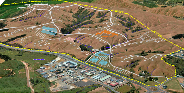
Plimmerton Farm: getting greenfields right
- Talk Wellington
- If we’re hellbent on doing more residential development in greenfields, what does “decent” look like in Plimmerton, hilly land near an existing suburb – like most of our region’s greenfields? This post is basically a guide for anyone who cares about Plimmerton, good urban development, or healthy wetlands, streams and coast, but is time-poor and can’t face going through the truckloads of documents they’ve stuck up without any specific meta-guidance (some FAQ are here). Hopefully this will help you pop in a submission! PCC’s “information” pages they suggest you use for submitting. Every one of these is a large PDF document, 90% written in technical language… aargh! The background: what where and how For those who don’t know, Plimmerton Farm’s a big proposed subdivision of hilly farmland draining into the significant Taupō Wetland and to Plimmerton Beach, just over the train line and highway from Plimmerton village (original Ngāti Toa name: Taupō). It’s going through a Streamlined Planning Process, a pre-COVID government scheme for accelerating development. The key step is the requisite change of the land’s zoning in the Porirua District Plan (“rural” zone to “residential” and other “urban” zones) that sets out what kind of stuff can then be built, where. It’s mostly streamlined because there’s just one shot for the public to have input on the plan change. One shot. Why submit? I was born and raised in Plimmerton, live here now, and intend to for the rest of my days. I’d love to see it grow, well. I would love Plimmerton to get more wallets, more hearts and minds, more faces (more diverse ones too!). But not with more traffic, and pointless damage to our environment. Right now, the proposal has some serious flaws which need sorting. I say Sorting because the changes won’t make it crazy innovative, just good enough for a development in the spot it is, being kicked off in 2020. Time matters too: there’a a bunch of good things happening imminently (and some bad Porirua trends that need to be reversed). I cover these in Get it right, below. It’s worth submitting because given the situation, a 1990s-grade development just won’t cut it. So what about Plimmerton Farm needs to change? It boils down to two themes: dial down the driveability and dial up the liveabilitymake Local the logical and easy choice for daily needs I’ll outline what needs to change in each. NOTE: There’s a third – don’t stuff the wetlands and streams. This is really important as Taupō Wetland is regionally significant, and all our streams and harbours have suffered from frankly shameful mismanagement of sediment from earthworks-heavy subdivisions like Aotea and Duck Creek, and from the earthworks-a-rama of Transmission Gully. Friends of Taupo Swamp have an excellent submission guide for you – add in some of their suggested bits to your submission. I: Dial down the driveability, dial up the liveability There aren’t many truly black-and-white things in life, but there’s one for towns: If a street is nice to drive in, it’ll be a crappy place to do anything else in (walk / eat / hang out / have a conversation / play / scoot or cycle / shop / have a pint). If it’s nice to do anything else in, it’ll be a crappy place to drive in. Mostly this is because of the nature of the automobile: big solid things that smash into our soft bodies if someone makes a mistake (75% odds of death if that’s at 50km/hour, 10% odds of death if at 30km/hour) big objects that need lots of space for manoeuvering and especially parking – which offstreet can be crazy expensive and push up the cost of a home, and onstreet hoover up valuable public space. big solid things driven by us real humans (for a while at least) who respond to the environment but also get distracted, and generally aren’t good at wielding these big solid things safely. The transport setup proposed for Plimmerton Farm makes for a much too driveable and poorly liveable place. 1. Narrow down all the roads. The current proposal’s roading setup has roads and streets that are too big, and there’s too much of them. Right sized roads for a liveable community The cross-sections for the roads include on-street parking and really wide lane widths. This is really gobsmacking for a consortium that talked a big talk about good practice. For all the reasons that Low Traffic Neighbourhoods are good, this is bad. (And it’s especially nuts when you realise that the excessively wide “arterial” roads (11 metres!) will need earthworked platforms built for them where they’re drawn running up the sharp ridges and across the tops of gullies. Expensive, damaging for the environment, and … what were they thinking?) So recommended changes: NARROW DOWN THE ROADS. Seriously. Design all the living-area streets and roads, and the centre, to be self-explaining for an operating traffic speed of 30km or less – that’s the speed where mistakes are rarely fatal. What does that look like? The designers will know and if they don’t they should be fired. Narrower crossing distances; chicanes (great way to incorporate green infrastructure and trees and seating!); narrowed sight-lines (trees! sculpture!) so no-one driving feels inclined to zoom. Reduced trafficked lanes (rori iti on the larger roads!), with properly wide and friendly footpaths. Threshold treatments, humps, modal filters, all the things we know very well are the natural ways to slow us down when driving, and make streets nicer for people. The beauty of all this “restriction” on driving is how much it frees us up for making everything else appealing. Streets become hospitable for kids to walk, scoot, bike to school safely, using the road not the footpath. Older people and those with impairments can walk and wheelchair safely. Teens coming home from town of an evening can scoot or bike home, safely. Popping down to the shops or for a coffee or to the train becomes a pleasure to do on foot, or on a scooter or bike. And you’re moving in a legitimate way – seeing and being seen, not stuck off in the bush on a “recreational” track like what they’ve described. The ordinary streets and roads are walkable, bikeable, scootable, mobility-scootable, and perfectly driveable, equally safe and useable in all weathers and anytime of day or night. Used to be a big, fast road. Now, kids bike to school and old people can chill out on it. (Mark Kerrison) (And in case you’re worried about firetrucks / rubbish trucks / buses, recall that on even Wellington City’s far more winding, narrower hilly streets everyone gets their rubbish collected and fires fought just fine. On public transport, smaller buses, like those that community transport operators use, are the way of the future for less densely-populated areas like this). Don’t build the through and loop roads. You don’t need signs like this when the only people who bother to drive in are those who live there, or who are visiting friends, because you just have to drive out again the way you came. When it’s the place you live, you’re invested in not being a dick far more than if you’re just out for a drive – or worse, out for a bit of a boyrace hoon on a massive loop route through a whole place. So just don’t build those big connector roads that enable people to drive easily from one residential area to the next, especially the ones up in the hilltops (section C) that just say “come for a hoon!” Instead, connect the living spaces heavily with bikeable, walkable, scootable, disability-friendly streets and lanes, and as much as possible, only one way in and out for cars from each living area. II: Make local logical and easy Plimmerton is a true village, with a great little centre (including a train station!) but Plimmerton Farm is ultimately a damn big area. The way to go is to enable people to get the basics of life – like school, groceries, a coffee – with a little local trip on foot, bike or scooter – it’s more of a bother to get in the car. Right now though, it needs two changes: 1. Provide for a second centre “Bumping into” spaces are known to be crucial to a feeling of neighbourhood, and in the (initial) absence of third places (worship places, community hall, sports club, cafe/pub, a supermarket is a vital social centre. Yet the north end of Plimmerton Farm is currently a deadzone for anything except residential. What things will probably look like under current layout. Like in Edwards Scissorhands without the interest of a castle. There’s no provision for a place to do your household groceries, so people will drive to Mana New World – more car trips – and less opportunity to bump into people who live nearby. (There’ll be no school in Plimmerton Farm for a while, because Ministry of Education isn’t allowed by the Education Act to build a school somewhere until there’s a certain population density of kids to fill it. A shitty Catch-22 for developments which is hopefully going to be fixed … sometime. Just another reason to make walking, biking and scooting really kid-friendly, as extra dropoff traffic for kids going to St Theresa’s, Plimmerton School, Paremata and Pukerua Bay schools will be a nightmare.) So they should provide for an additional centre in the north, including a groceries place of some kind. 2. Intensify within walking distance of Plimmerton proper. We should intensify properly, with lots of medium and even some high density (6 storeys of nicely laid-out density done well!) in the area that’s within a 5-minute walk of Plimmerton Village. The more people can live and work with access to all its many amenities, and its rail station (10 min to Porirua, 30 min to Wellington), the better. But there’s not enough density provided for there. Plimmerton Railway station: buzzing in 1916 and has only got bigger. (Photo: Pātaka Porirua Museum) So they should add another zone – E – of higher density in that 5-minute walking catchment of Plimmerton Village. What could it look like? A good example is 3333 Main, Vancouver . Submission tips On the site they ask you to fill in a Word or PDF form, saying which specific bit of the gazillion proposals you are talking about and the specific changes you want. This is a BS way to treat the vast majority of people submitting: normal non-professionals, just regular people who care about good development and liveable places. So just don’t worry about that. In those question 6 column boxes just put “Transport” and “Layout”. It’s the professional planners’ job to figure out specifically how to change a planning document. Just be specific enough that they know what you want to see. The text above is worth copying and pasting – it’ll be enough. And don’t forget the Friends of Taupo Swamp and Catchment advice is essential – definitely go read and use. That’s all you really need – just go submit! But if you’re keen to know more reasons why they should be doing this better, here’s some… Get it right, now Once this plan change is through, traditional developers like Gillies like to whack in all the infrastructure – hello, massive earthworks. And yet the place will take decades to fill with actual people – those hearts and minds and wallets. (Note even before COVID, Porirua’s growth rate was 0.1% per year. Yep, one tenth of one percent.) And extra pressure’s on to do this better because all these things are features of the next one to three years: the One Network Road Classification (sets the design specs for roads of different types) is being updated right now to be more people-friendly in the specs for roads in residential and centre areas, so designs like Plimmerton Farm’s will soon be Officially Bad Practice Sales and riding of e-bikes and e-scooters are going through the roof, continuing through and beyond COVID – this shows no signs of slowing, and prices are dropping. E-power flattens the hills of Plimmerton Farm and makes wheely active travel a breeze for the middle-class people who’ll be living here, if the streets and roads are hospitablePlimmerton Railway Station (on the most popular Wellington train line) is being upgraded to be a terminus station – i.e. better servicesThe Wellington Regional Growth Framework is setting a bunch of directions for councils on how to grow well, including well-known but often well-ignored issues like intensifying around public transport hubs Councils will soon be required to do to a bunch of a bunch of international good practice including get rid of many minimum parking requirements (in the news lately), and to upzone (enable intensification) of landuse in the walking catchment of public transport hubs. (5 min walk = approx 400 metres, 10 min = 800m).Bad trends we need to stop: Porirua’s really high car-dependency (we own cars a lot and drive a lot) is continuing, due to car-dependent urban form [PDF]– despite nice words in council’s strategic intentions.People living outside Wellington City are mostly to blame for our region’s 14% increase in emissions from transport in just 10 years. OK go submit now – and share with anyone who you think might care!
- Accepted from Talk Wellington posts by feedreader
- Tagged as:
- paremata
- porirua
- transmission-gully
- sculpture
- government
- parking
- design
- covid-19
- law
- planning
- wellington
- education
- developments
- sport
- buses
- coffee
- zoo
- people
Transmission Gully Motorway, Kenepuru, Porirua, Porirua City, Wellington, 5022, New Zealand (OpenStreetMap)
-
-
-
Submission to Wellington City Council on Parking Policy
- Oriental Bay Residents’ Association
- Submission to WCC on Parking Policy, 6 June 2020Jackie Pope/Ann Mallinson, Co-Presidents, Oriental Bay Residents Association The Oriental Bay Residents Association has considered the Parking Policy 2020 Statement of Proposal, and would comment as follows: We assume we come under the category City Fringe and Inner City Suburbs.
- Accepted from Oriental Bay Residents’ Association 2019 by feedreader
- Tagged as:
- oriental-bay
- fringe-festival
- parking
- wellington
- wellington-city-council
Oriental Bay, Wellington, Wellington City, Wellington, 6011, New Zealand (OpenStreetMap)
-
-
-
WCC Parking Policy Proposal
- Hataitai Community Website
- WCC are asking Wellingtonians to go online and provide feedback on the Parking Policy Proposals.
- Accepted from Hataitai Community website posts by feedreader
- Tagged as:
- parking
- wellington
- wellington-city-council
-
-
-
Minutes of the March 2020 Meeting
- Newtown Residents' Association
- Minutes of the Newtown Residents’ Association meeting 16th March 2020 Present: Rhona Carson (Chair), Steve Cosgrove (Minutes), Leonie Walker, Jane Patterson, Jill Ford, Alison Borbelly, Keith Powell, Tom Law, Don McDonald, Warwick Taylor, Peter Frater, Effie Rankin, Faye Tohbyn, Lyn Morris, Sam Somers, Eileen Brown, Neville Carson, Kevin Lethbridge, Graeme Carroll, Merio Marsters, Marion Leighton. Apologies: Paul Eagle, Dom Shaheen, Steve Dunn, Martin Hanley, Anna Kemble Welch, Jan Gould + Marion Leighton(for lateness)Noted that Paul apologised because MPs have been advised to stay away from community meetings due to Covid-19 risks.. Rhona welcomed everyone to the meeting. Newtown Festival Rhona thanked all the marshalls and other volunteers for helping. The meeting made an enthusiastic vote of thanks and appreciation to the organisers for another very successful Festival.Sadly there was one violent event later in the evening; this seemed to be the result of a personal conflict between two visitors to Newtown. The Police and Community Patrol were involved. Don asked what the noise policy is, as he worries about how loud the Festival is. Tom Law outlined the Council policy. Wellington City Council Consultations Parking Policy. Consultation opened today and will run till April 14th. WCC had a traveling road show on the subject in Newtown Mall this morning. It wasn’t widely advertised and no one at the meeting knew it was going to be there, or attended.Rhona noted that the policy is very high-level at this stage. We recommend that people look at the material on the website. The questions on the web site are quite general so Newtown-specific concerns would need to be added in narrative form.Some general issues were discussed.We will consider different things we can agree on, such as further communication with WCC to develop a Newtown-specific plan, and sensible Residents’ Parking areas and fees. Planning for Growth The WCC Consultation Team were to have a Newtown Festival stall but cancelled because they were not quite ready to go. Next consultation meeting is on 26 March at Prefab – Jane and Rhona interested in going. No one had any further comment: Rhona suggested reading the web page and keeping up-to-date with progress on the development of a proposed spatial plan for the city.District Plan Review – this is beginning at the end of this year or early next. Water Warrick is concerned that water metres are coming back into discussion. This has resulted in some suggesting we ‘need’ water metres to pay for replacement of aged infrastructure.A number of views were expressed regarding the pros and cons of water metering. COVID-19 Eileen Brown is working for the Council of Trade Unions developing plans and consolidating ideas for “managing the risk and flattening the curve”.The current situation was outlined, along with common narratives being used to describe the situation and management options. Eileen described then distributed some information.Marion Leighton (Consultant Physician at Wellington Hospital) arrived during this discussion, having been at a hospital meeting on the same topic. She outlined the hospital’s plans for managing an influx of seriously ill patients and also answered questions. Most important thing is to wash hands frequently and thoroughly, cough and sneeze into your elbow or tissues, don’t touch your face, avoid physical contact with others and self-isolate at the first sign of any symptoms. We are in this for the long-term, so make sure you have a reasonable plan. Emergency Management Discussion Neville Carson outlined his background in Civil Defence (previous name for Emergency Management, and introduced “Wellington Conversations” – facilitated conversations on various topics which have been running in Newtown and elsewhere for several months.Neville is organising a meeting to discuss Emergency Management issues on 31 March, 7:30 to 9:30, at Newtown Hall, using a model based on Wellington Conversations. Circus Performers – Steve informed the meeting that on Wednesday evening (18th Mcaarch) in Carrara Park circus performers will be performing with LED Hula hoops. Meeting ended at 8:58
- Accepted from NRA news by feedreader
- Tagged as:
- newtown
- wellington-city-council
- covid-19
- water
- consultation
- parking
- law
- planning
- wellington
- art
- noise
- hospital
- people
Newtown, Wellington, Wellington City, Wellington, New Zealand (OpenStreetMap)
-
-
-
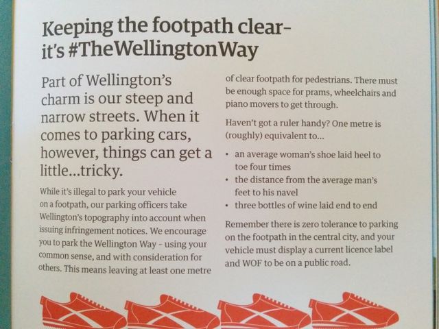
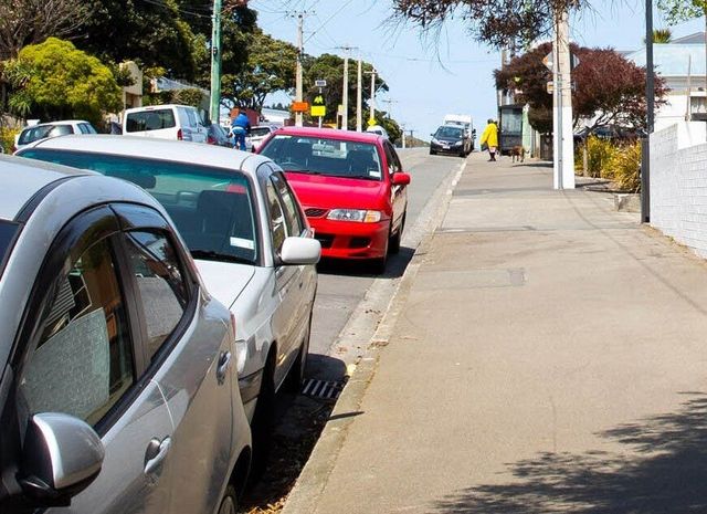
Keeping The Footpath Clear
- Sustainable Wellington Transport
- Wellington residents were delivered a copy of Our Wellington within the last week and we were disappointed to see this bit contained within.
- Accepted from Sustainable Wellington Transport posts
- Tagged as:
- wellington-city-council
- parking
-
-
-
Living in fear of a car parking fine
- Sarah Free
- Many have commented recently on the issue of over-zealous car parking wardens in the city, and some have stated a desire to see parking enforcement (and even parking buildings themselves!) bought back under direct Council control.
- Accepted from Sarah Free posts
- Tagged as:
- wellington-city-council
- parking
-
-
-
In praise of Wellington’s spy car
- Wellington Scoop
- Kiwis are terrible drivers. Over the holidays, the news has been full of the consequences of our bad driving habits as the dead and maimed piled up across the country. Largely these victims were the consequences of basic driving errors – speeding, badly-judged overtaking moves, hit-and-run crashes, drinking and driving, and failing to put on a seat belt. We kill ourselves on the road at more than twice the rate of the UK and rank as one of the worst performers for road deaths in the OECD. And we’re no better around Wellington’s narrow streets, which is why the much-maligned “spy car” is such an essential tool. In the Wellington region, road deaths and injuries rose 10% last year, bucking the national trend.
- Accepted from Wellington Scoop features
- Tagged as:
- wellington-city-council
- spy-car
-
-
-
Council votes to consult on bus lanes
- Bryan Pepperell - Back To The Future
- Voting to consult on removing on-street motorcycle parks, car parks and loading zones on KENT TERRACE from MAJORIBANKS STREET TO EDGE HILL to be replaced with a Bus Priority Lane were: Mayor Wade-Brown, Councillors Ngaire Best, Stephanie Cook, Paul Eagle, Andy Foster, Justin Lester, Simon Marsh, Iona Pannett, Helene Ritchie.
- Accepted from Back To The Future
- Tagged as:
- motorcycling
- consultation
- wellington-city-council
- bus-lanes
- parking
-
-
-
Capital Row Over Parking Charges
- Auckland Trains
- The gloves are off in Wellington over Council plans to make Wellington the most expensive city in New Zealand to park in.
- Submitted by tonytw1
- Tagged as:
- parking
- wellington-city-council
-
-
-
The price of parking, the cost of leaks
- Wellington Scoop
- We learnt last week that the Wellington City Council earns $6000 every year from each of its pay-and-display parking spaces. The news came in a statement from the Mayor, responding to a DomPost report that the council was thinking of ending free parking for motorbikes and scooters. Not so, she said.
- Submitted by tonytw1
- Tagged as:
- parking
- wellington-city-council
-
-
-
Wellington’s Parking Space Dilemma
- Auckland Trains
- Wellington City Council confirms it’s reviewing motorcycle parking spaces in the city “to more effectively manage public space in the CBD.
- Tagged as:
- motorcycling
- wellington-city-council
- parking
-
-
-
Getting off parking tickets – ask your council how
- WCC Watch
- This year’s Ombudsmen annual report to Parliament, tabled last week, had an interesting discussion on the disclosure requirements around the rules governing parking ticket waivers (page 39).
- Tagged as:
- parking
-
-
-
Wellington City parking supremo dies in Sydney
- WCC Watch
- The founder of Tenix, Carlo Salteri, died on Tuesday night in Sydney, aged 89 according to a Sydney Morning Herald report.
- Tagged as:
- parking
-
-
-
What to do with parking fines?
- Wellington Scoop
- After claims that Wellington parking wardens were given ipods and overseas trips to encourage revenue gathering, the Wellington City Council put an end to the speculation – there was just one ipod, and one overseas trip. Both prizes were gifted in a warden’s competition which had nothing to do with how much revenue they’d collected. Fair enough, too. Many employees are offered rewards for a whole range of reasons. But public perception is hard to shake. So, what should the council do? Here’s an idea that’s guaranteed to please everybody. Well, nearly everybody.
- Tagged as:
- wellington-city-council
- parking
-