-
 geotagged newsitems feed
Geotagged / Parking
Near me
-
-
Skills training on Wednesday and AGM updates
- Wellington Orienteering Association
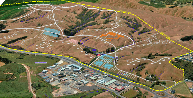
- Skills training on Wednesday and AGM updates Last-ditch skills training for the year on Kaukau this Wednesday ͏ ͏ ͏ ͏ ͏ ͏ ͏ ͏ ͏ ͏ ͏ ͏ ͏ ͏ ͏ ͏ ͏ ͏ ͏ ͏ ͏ ͏ ͏ ͏ ͏ ͏ ͏ ͏ ͏ ͏ ͏ ͏ ͏ ͏ ͏ ͏ ͏ ͏ ͏ ͏ ͏ ͏ ͏ ͏ ͏ ͏ ͏ ͏ ͏ ͏ ͏ ͏ ͏ ͏ ͏ ͏ ͏ ͏ ͏ ͏ ͏ ͏ ͏ ͏ ͏ ͏ ͏ ͏ ͏ ͏ ͏ ͏ ͏ ͏ ͏ ͏ ͏ ͏ ͏ ͏ ͏ ͏ ͏ ͏ ͏ ͏ ͏ ͏ ͏ ͏ ͏ ͏ ͏ ͏ ͏ ͏ ͏ ͏ ͏ ͏ ͏ ͏ ͏ ͏ ͏ ͏ ͏ ͏ ͏ ͏ ͏ ͏ ͏ ͏ ͏ ͏ ͏ ͏ ͏ ͏ ͏ ͏ ͏ ͏ ͏ ͏ ͏ ͏ ͏ ͏ ͏ ͏ ͏ ͏ ͏ ͏ ͏ ͏ ͏ ͏ ͏ ͏ ͏ ͏ ͏ ͏ ͏ ͏ ͏ ͏ ͏ ͏ ͏ ͏ ͏ ͏ ͏ ͏ ͏ ͏ ͏ ͏ ͏ ͏ ͏ ͏ ͏ ͏ ͏ ͏ ͏ ͏ ͏ ͏ ͏ ͏ ͏ ͏ ͏ ͏ ͏ ͏ ͏ ͏ ͏ ͏ ͏ ͏ ͏ ͏ ͏ ͏ ͏ ͏ ͏ ͏ ͏ ͏ ͏ ͏ ͏ ͏ ͏ ͏ ͏ ͏ ͏ ͏ ͏ ͏ ͏ ͏ ͏ ͏ ͏ ͏ ͏ ͏ ͏ ͏ ͏ ͏ ͏ ͏ ͏ ͏ ͏ ͏ ͏ ͏ ͏ ͏ ͏ ͏ ͏ ͏ ͏ ͏ ͏ ͏ ͏ ͏ ͏ ͏ ͏ ͏ ͏ ͏ ͏ ͏ ͏ ͏ ͏ ͏ ͏ ͏ ͏ ͏ ͏ ͏ ͏ ͏ ͏ ͏ ͏ ͏ ͏ ͏ ͏ ͏ ͏ ͏ ͏ ͏ ͏ ͏ ͏ ͏ ͏ ͏ ͏ ͏ ͏ ͏ ͏ ͏ ͏ ͏ ͏ ͏ ͏ ͏ ͏ ͏ ͏ ͏ ͏ ͏ ͏ ͏ ͏ ͏ ͏ ͏ ͏ ͏ ͏ ͏ ͏ ͏ ͏ ͏ ͏ ͏ ͏ ͏ ͏ ͏ ͏ ͏ View this email in your browser Training this Wednesday and AGM updates Meri Kirihimete <>! After the successful and fun afterwork series—and before you check out for the holidays—we are putting on a training session focussing on compass skills. The training will occur on Kaukau, at 6—7pm Wednesday, 17 December. Our session is aimed at those wanting to learn new skills and techniques, or those with more experience who want to practise their techniques, and is suitable for every ability (kids and adults welcome!). Bring your compass and clothes suitable for the weather, as it can be exposed on the tops. No dogs are allowed on the farmland. The session will be coached by Rachel and Yvette Baker, so please email Rachel at rachel.rosara.baker@gmail.com if you have any questions, or need to borrow a compass. On-street parking is available at our meeting point at the end of McLintock Street, accessed from Truscott Avenue. See the map. Key takeouts from the AGM If you missed the AGM, don’t worry. Here are some of the key takeouts. “This year has been one of growth, development, and community spirit as we continue to promote and enhance the sport of orienteering across the Wellington region.”—Beverley Holder, President You can read more about our club achievements—events, training, mapping and more—in Beverley’s report below. There will be no change to subscription fees for 2026. President’s report Committee and working groups As elected committee for 2026 is: Beverley Holder (President) Gerald Crawford (Treasurer) Lachlan McKenzie Jake Hanson Paul Teasdale-Spittle The committee will be supported by working groups to fulfil the club’s many functions. Working groups have been proposed but not confirmed, and are not necessarily permanent—they may be based around time-bound projects. We’d love to hear from you about which groups you think might be useful, and how you may like to contribute. Read the discussion paper and send your thoughts to Lachlan at secretary@wellingtonorienteering.org.nz Discussion paper Awards Congratulations to our award recipients this year. The Endeavour Cup is awarded for development and performance, and the Fortune Cup is awarded for outstanding service to the club. Endeavour Cup Rachel Baker received this year’s Endeavour Cup for her outstanding performances including as part of the New Zealand team at this year’s Junior World Orienteering Championships in Italy. Other nominees were Morag McLellan and Jake McLellan. Fortune Cup Alan Horn received the Fortune Cup. Alan unfailingly provides outstanding support for events, gear, and controlling and planning. Other nominees were Paul Teesdale-Spittle, Helen Hughes, Lachlan McKenzie and Will Vale. Members’ League We will be trialling a members’ league in 2026—a way to introduce some fun competition into events where scores are based on comparative performance, rather than absolute as per race time. Details are being worked through but generally will look like this: For members age 16 or over who run a Red-level course CSWs and OYs will be ‘counting events’ Scores will be allocated based on the formula “Average km rate * (age and gender weighting)” Overall winner: If there are 10 ‘counting events’, we will take your top 6 scores. Coming events Orienteering Wellington’s coming events can be found on our Events page. You can also toggle the calendar to show Orienteering Hutt Valley’s events. Sprint, Whitireia Campus – Wednesday 11 February Sprint, Victoria University – Wednesday 25 February Sprint, Masey University – Wednesday 11 March CSW, Tikara, Churton Park – Sunday 23 March For all events, visit Orienteering New Zealand. About us We welcome all who live around Te Whanganui-a-Tara to discover our special region through orienteering. Be part of our community at Orienteering Wellington. Copyright (C) 2025 Orienteering Wellington. All rights reserved. Our mailing address is: Want to change how you receive these emails? You can update your preferences or unsubscribe
- Accepted from Wellington Orienteering Association feed 2024 by feedreader
- Tagged as:
- hutt-valley
- dogs
- orienteering
- parking
Lower Hutt, Wellington, New Zealand (OpenStreetMap)
-
-
-
August 2025 - A blizzard of activity
- Wellington Orienteering Association
- August 2025 - A blizzard of activity ͏ ͏ ͏ ͏ ͏ ͏ ͏ ͏ ͏ ͏ ͏ ͏ ͏ ͏ ͏ ͏ ͏ ͏ ͏ ͏ ͏ ͏ ͏ ͏ ͏ ͏ ͏ ͏ ͏ ͏ ͏ ͏ ͏ ͏ ͏ ͏ ͏ ͏ ͏ ͏ ͏ ͏ ͏ ͏ ͏ ͏ ͏ ͏ ͏ ͏ ͏ ͏ ͏ ͏ ͏ ͏ ͏ ͏ ͏ ͏ ͏ ͏ ͏ ͏ ͏ ͏ ͏ ͏ ͏ ͏ ͏ ͏ ͏ ͏ ͏ ͏ ͏ ͏ ͏ ͏ ͏ ͏ ͏ ͏ ͏ ͏ ͏ ͏ ͏ ͏ ͏ ͏ ͏ ͏ ͏ ͏ ͏ ͏ ͏ ͏ ͏ ͏ ͏ ͏ ͏ ͏ ͏ ͏ ͏ ͏ ͏ ͏ ͏ ͏ ͏ ͏ ͏ ͏ ͏ ͏ ͏ ͏ ͏ ͏ ͏ ͏ ͏ ͏ ͏ ͏ ͏ ͏ ͏ ͏ ͏ ͏ ͏ ͏ ͏ ͏ ͏ ͏ ͏ ͏ ͏ ͏ ͏ ͏ ͏ ͏ ͏ ͏ ͏ ͏ ͏ ͏ ͏ ͏ ͏ ͏ ͏ ͏ ͏ ͏ ͏ ͏ ͏ ͏ ͏ ͏ ͏ ͏ ͏ ͏ ͏ ͏ ͏ ͏ ͏ ͏ ͏ ͏ ͏ ͏ ͏ ͏ ͏ ͏ ͏ ͏ ͏ ͏ ͏ ͏ ͏ ͏ ͏ ͏ ͏ ͏ ͏ ͏ ͏ ͏ ͏ ͏ ͏ ͏ ͏ ͏ ͏ ͏ ͏ ͏ ͏ ͏ ͏ ͏ ͏ ͏ ͏ ͏ ͏ ͏ ͏ ͏ ͏ ͏ ͏ ͏ ͏ ͏ ͏ ͏ ͏ ͏ ͏ ͏ ͏ ͏ ͏ ͏ ͏ ͏ ͏ ͏ ͏ ͏ ͏ ͏ ͏ ͏ ͏ ͏ ͏ ͏ ͏ ͏ ͏ ͏ ͏ ͏ ͏ ͏ ͏ ͏ ͏ ͏ ͏ ͏ ͏ ͏ ͏ ͏ ͏ ͏ ͏ ͏ ͏ ͏ ͏ ͏ ͏ ͏ ͏ ͏ ͏ ͏ ͏ ͏ ͏ ͏ ͏ ͏ ͏ ͏ ͏ ͏ ͏ ͏ ͏ ͏ ͏ ͏ ͏ ͏ ͏ ͏ ͏ ͏ ͏ ͏ ͏ ͏ ͏ ͏ ͏ ͏ ͏ ͏ View this email in your browser August 2025 news Kia ora koutou There’s been a blizzard of activity this winter, including member successes and fantastic events like Hydrabad, Khandallah Score, Mill Creek, Baring Head, the Whitby night event and Matariki/Waikawa weekend special. Our practical training at Karori Park saw a fantastic turnout of some 50 new and developing orienteers, with a number of members volunteering their time to coach groups around a set course. If you missed these great events and have FOMO, you can check out the maps on the events and results page of our website. Our new Constitution was accepted by members at a Special General Meeting in June. This allows us to comply with the new Incorporated Societies Act 2022, enabling Orienteering Wellington to remain registered as an incorporated society. We hope this Constitution will serve us well, but it is new to our club. If there are things that you don’t feel are working in the best interests of the club then let the Committee know, so that we can bring these to members’ attention for consideration at Annual General Meetings. Beverley Holder President Participants ready themselves for the Whitby night courses. Major events on the horizon Pokapū Regional Championships are just around the corner at Labour Weekend (25 – 7 October), hosted by Red Kiwis. A sprint will be held in Palmerston North, while the long and middle events will be at Santoft forest. Entries open soon—don’t miss this orienteering bonanza! Tūāraki (Northern) Regional Champs (8 – 9 November) will be hosted by Orienteering Bay of Plenty andTaupō Orienteering Club. Events will be near Rotorua, on the Opepe and Lake Okataina maps. Entries are open. Find out more. Our Spring Classic will be on Sunday 23 November on a new map in Waikanae. The Classic is a longstanding endurance event, the course incorporating relay loops (which competitors run solo) followed by a longer conventional course. The M40 class incorporates the Wayne Cretney Memorial that commemorates Wayne, a Wairarapa orienteer who was tragically killed in an accident in 1988 at the age of 44. All Orienteering Wellington members are invited to our End‑of‑year social on Saturday 6 December! It’s a great chance to look back on and celebrate a busy year, swap stories, and agonise over “the run that got away”. More details coming soon. 50th‑Birthday celebrations: Orienteering Wellington turns 50 next year—our golden jubilee! That’s quite a milestone, and we’ll be marking the occasion with festivities in the middle of next year. Stay tuned! Young ‘uns, young guns! Younger Orienteering Wellington members shone in Europe. Rachel Baker was part New Zealand’s Junior World Orienteering Champs team in Trentino, Italy (26 June – 3 July). She placed 65 in the sprint, 21 in the long, and 39 in the middle, and was a member of the sprint and forest relay teams that placed 42 and 15 respectively. Rachel went on to the World Orienteering Champs in Kuopio, Finland (8 – 12 July), where she brought the Women’s relay team into eighteenth position after the first leg. She also placed 38 in the middle-distance event. Jake McLellan smashed his way to seventh place at the Junior World Orienteering Champs sprint, 28 on the long and 75 for the middle event. The men’s relay team of which he was part placed 15. We’re super proud of Rachel and Jake, who performed outstandingly. Another of our young stars, Morag McLellan, was selected to represent New Zealand at the European Youth Orienteering Champs Brno, Czechia (17 – 20 July) but sadly unable to attend. And a correction… Our May newsletter featured Jake McLellan’s massive (non-orienteering) achievement of winning the Tararua Mountain Race. His win was significantly more epic than stated – a chip time of 5:07:12 (some two hours less than we gave him credit for!). Our apologies, Jake. Quiz: Which map? This may not have been your course, but do you recognise this recent map? The answer is at the bottom. Explore our permanent courses We’ve been checking our two permanent courses – on Wellington’s Waterfront and Matairangi (Mount Victoria) – are in order and that maps and plaques are current. These central city DIY courses are perfect for training, casual outings, or introducing others to orienteering. Please explore them and share them with your friends! You can download maps and instructions for permanent courses on our website. Explore permanent courses Nationals at Easter 2026 – Pack your bags for the Wairarapa At Easter 2026 (3-6 April), Orienteering Wellington is leading the charge to host the NZ Orienteering Championships (Nationals), with support from Red Kiwis, Orienteering Hutt Valley and Orienteering Wairarapa. Events will be in the Wairarapa and embargoed areas have been published on the ONZ website: · Sprint: Rathkeale College, Masterton · Middle: Rewanui Forest Park, Blairlogie (east of Masterton) · Long: Coonoor, east of Pahiatua · Relay: Riverside Farm, northwest of Masterton Nationals 2026 Nationals will likely attract more than 500 orienteers from around New Zealand and promises to be a standout event—please help make it legendary, both as a competitor and on the volunteer squad. Speaking of which….. You are key to our events! Your help at events makes all the difference—whether it’s on the computer, starts, registration, control collection, set-up, pack-down, parking or something else, we need hands on deck. Helping is a great way to meet others and don’t worry if you haven’t done a job before—we’ll show you the ropes. You don’t have to be a member to help either, and all volunteers enjoy a free run at that event. We are always looking for people who are interested in planning or controlling events. If this sounds like you then get in touch or rock on up to the desk at the next event. If you haven’t planned an event before then we’ll make sure you’re paired with someone who can help. The key thing is to allow plenty of time to realise your best possible courses. We’ve also published some basic resources specific to Orienteering Wellington events, which are a “must read” for all planners and controllers. Quiz answer The map shows part of the yellow course on the Waikawa map. Participants line up to start Waikawa. Coming events Orienteering Wellington’s coming events can be found on our Events page. You can also toggle the calendar to show Orienteering Hutt Valley’s events. Sunday 17 August – Score event, Kaitoke Monday 18 August – Mapper training, Lower Hutt Sunday 31 August – Score event, Mount Albert Sunday 7 September – Newlands Wednesday 10 September – Afterwork Rogaine, Brooklyn Wednesday 8 October – Afterwork Rogaine, Ōtari Sunday 12 October – OY, Waitārere Sunday 12 October – Training, Hydrabad map, Waitārere … For all events, visit Orienteering New Zealand About us We welcome all who live around Te Whanganui-a-Tara to discover our special region through orienteering. Be part of our community at Orienteering Wellington Copyright (C) 2025 Orienteering Wellington. All rights reserved. Our mailing address is: Want to change how you receive these emails? You can update your preferences or unsubscribe
- Accepted from Wellington Orienteering Association feed 2024 by feedreader
- Tagged as:
- khandallah
- waikanae
- parking
- wairarapa
- mount-victoria
- waterfront
- newlands
- lower-hutt
- orienteering
- brooklyn
- karori
Lower Hutt, Lower Hutt City, Wellington, 5010, New Zealand (OpenStreetMap)
-
-
-
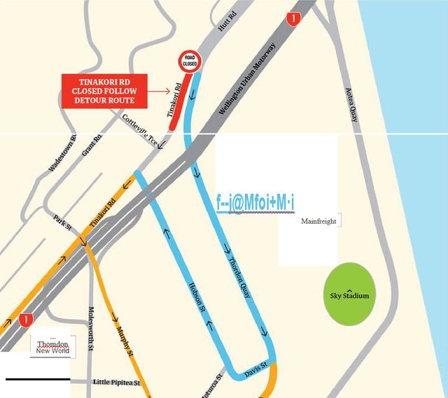
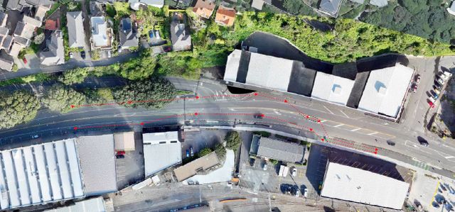
Roadworks update – Tinakori Road/Thorndon Quay/Hutt Road
- Thorndon Residents Assocation
- This is a reminder notice of upcoming night works to surface and line mark the road at the intersection of Tinakori Road and Thorndon Quay. We informed you in the first notification letter that there would be a road closure for the lower section of Tinakori Road to complete surfacing due to this road being […]
- Accepted from TRA news 2019 by wellynews
- Tagged as:
- thorndon
- parking
Thorndon, Wellington, Wellington City, Wellington, New Zealand (OpenStreetMap)
-
-
-
Roadworks Notice – Tinakori Road / Thorndon Quay / Hutt Road
- Thorndon Residents Assocation
- As part of the Thorndon Quay, Downer have been upgrading the intersection at Tinakori Road and Thorndon Quay to be a signalised intersection with traffic lights. As day works are almost finished, there are final night works to complete construction in the area. These works in clude surfacing, line marking and the installation of the […]
- Accepted from TRA news 2019 by tonytw1
- Tagged as:
- thorndon
- parking
Thorndon, Wellington, Wellington City, Wellington, New Zealand (OpenStreetMap)
-
-
-
Thorndon Quay Upgrade Project – January 2025
- Thorndon Residents Assocation
- Construction update 2025 - Biking through Thorndon Quay, Cycleway surfacing and parking, Neat Places - neat results, Microgrants supporting small businesses, Whakahikuwai Awa karakia
- Accepted from TRA news 2019 by tonytw1
- Tagged as:
- thorndon
- island-bay-cycle-way
- parking
Thorndon, Wellington, Wellington City, Wellington, New Zealand (OpenStreetMap)
-
-
-
The Wrap Up (Term 4, Week 3 2024)
- Wellington High School
- Join the rapturous applause for our students representing Wellington in the U18 Girls team who struck gold at the UWH National. Delight your taste buds with new menu options at the school canteen and keep up-to-date with changes to the school car parking system. This and much more in this week's Wrap Up.
- Accepted from WHS 2019 by feedreader
- Tagged as:
- parking
Wellington High School, Taranaki Street, Mount Cook, Wellington, Wellington City, Wellington, 6011, New Zealand (OpenStreetMap)
-
-
-
Wadestown Residents Oppose Council parking, cycle changes
- Better Wellington
- Wadestown residents have rejected revised proposals from the Wellington City Council that they say would fundamentally change the character of the suburb by installing a restrictive parking management plan and...
- Accepted from Better Wellington posts by feedreader
- Tagged as:
- wadestown
- parking
- wellington-city-council
Wadestown, Wellington, Wellington City, Wellington, 6140, New Zealand (OpenStreetMap)
-
-
-
Agm
- Guardians of the Bays
- Guardians of the Bays Annual General Meeting will be: On Wednesday 15 May at 7.30pm At the Strathmore Park Community Centre – Te Tūhunga Rau Location 108 Strathmore Ave, Strathmore Park Vehicle entrance is below the building with parking at the rear or on the street The AGM will be held both at Te Tūhunga […]
- Accepted from Guardians of the Bays posts by feedreader
- Tagged as:
- strathmore
- parking
Strathmore Park, Wellington, Wellington City, Wellington, 6242, New Zealand (OpenStreetMap)
-
-
-
More Pedestrians on Cuba St Will Destroy Business, Say Campaigners
- Salient
- A coalition of business owners on Cuba St are petitioning the Council to reconsider its plan to remove 20 car parks along the stretch of road between Ghuznee and Vivian. Organised by (unsuccessful) Lambton Ward candidate and famed Kaffee Eis creamslinger, Karl Tiefenbacher, the “Park It” campaign hinges itself on business owners arguing that losing the 20 car parks will make a significant impact on their profit margins. “The thing to remember is that a lot of people walk here, obviously, and I get stupid statements like, ‘cars don’t spend money, people do’, but cars don’t drive themselves either, so every car brings an extra person to Cuba St,” he told Salient. “You know, we’re selling a low cost product, and we need a lot of turnover, so if we lose something like 10% of our business [by having no car parks], that’s enough to send us under.”
- Accepted from Salient 2024 by tonytw1
- Tagged as:
- cuba-street
- parking
Cuba Street, Te Aro, Wellington, Wellington City, Wellington, 6011, New Zealand (OpenStreetMap)
-
-
-

EV Charging Stations: Thorndon Pool
- Thorndon Residents Assocation
- Land use consent is sought for the installation and operation of electric vehicle (EV) charging stations at 20 locations across Wellington City. This includes retrospective consent for chargers which have already been installed at two locations. A resource consent application for installation of EV chargers at 26 Murphy Street (Thorndon Pool) has been notified. If […]
- Accepted from TRA news 2019 by tonytw1
- Tagged as:
- thorndon
- electric-vehicles
- parking
- consultation
Thorndon Summer Pool, Murphy Street, Thorndon, Wellington, Wellington City, Wellington, 6140, New Zealand (OpenStreetMap)
-
-
-
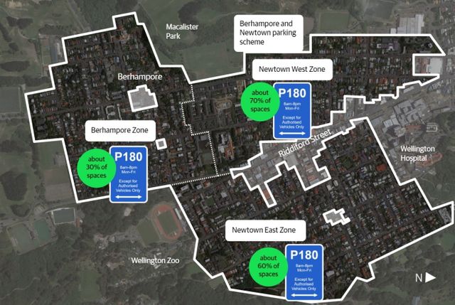
Berhampore and Newtown parking scheme – have your say by Feb 19th @ 1pm
- Island Bay Residents' Association
- https://www.
- Accepted from Island Bay Residents' Association feed by feedreader
- Tagged as:
- parking
- consultation
- berhampore
- newtown-park
Newtown Park, Melrose, Wellington, Wellington City, Wellington, New Zealand (OpenStreetMap)
-
-
-
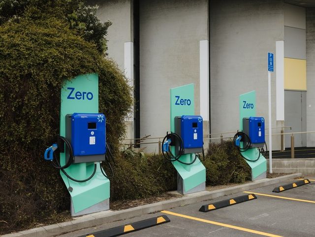
WCCC Proposed EV Charging Park on Williams Street
- Hataitai Community Website
- Wellington City Council is proposing changing some of the parking on William Street.
- Accepted from Hataitai Community website posts by feedreader
- Tagged as:
- electric-vehicles
- parking
William Street, Hataitai, Wellington, Wellington City, Wellington, 6021, New Zealand (OpenStreetMap)
-
-
-
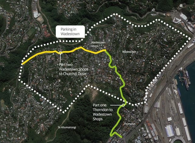
Wadestown Connections Street Changes Drop-in Sessions
- Thorndon Residents Assocation
- Wadestown drop-in sessions and advance notice of work starting Drop-in sessions in early February As part of developing a possible new parking scheme to help address parking pressures in Wadestown and designs for part two of Wadestown Connections, we’re holding drop-in sessions in the second week of February. You’ll be able to talk with the […]
- Accepted from TRA news 2019 by tonytw1
- Tagged as:
- wadestown
- parking
Wadestown, Wellington, Wellington City, Wellington, 6140, New Zealand (OpenStreetMap)
-
-
-
Berhampore and Newtown parking scheme
- Kōrero Mai | Let's Talk | Wellington City Council
- We'd like your feedback on the updated proposals for a parking scheme in Newtown and Berhampore. You can have your say until 1pm, Monday 19 February.
- Accepted from Kōrero Mai | Let's Talk current engagements by tonytw1
- Tagged as:
- parking
- consultation
- berhampore
- newtown-park
Newtown Park, Melrose, Wellington, Wellington City, Wellington, New Zealand (OpenStreetMap)
-
-
-
Berhampore- Newtown Parking Plan
- Newtown Residents' Association
- This proposed plan is based on the WCC Parking Policy which was agreed in 2020. Our Association supports the principle of residents having priority for parking on the residential streets. However we have concerns about the details of the proposal that was presented for consultation, and we are disappointed that the Parking Policy agreement for … Continue reading Berhampore- Newtown Parking Plan →
- Accepted from NRA news by feedreader
- Tagged as:
- consultation
- wellington-city-council
- parking
- berhampore
- newtown-park
Newtown Park, Melrose, Wellington, Wellington City, Wellington, New Zealand (OpenStreetMap)
-
-
-
Island Bay Village Public Space Upgrades and Parking in the village area
- Island Bay Residents' Association
- There have been a lot of comments circulating on social media since the concept designs for the Village upgrade were announced last week about the removal of parking spaces in Island Bay Village.
- Accepted from Island Bay Residents' Association feed by feedreader
- Tagged as:
- island-bay
- parking
The Parade, Island Bay, Wellington, Wellington City, Wellington, 6023, New Zealand (OpenStreetMap)
-
-
-
Introducing paid parking will hurt Porirua and should not go ahead
- Porirua Chamber of Commerce
- This morning the Porirua Chamber of Commerce made their submission against the City Council’s proposal to introduce paid parking in the CBD. "The Council’s…
- Accepted from Porirua chamber news 2020 by feedreader
- Tagged as:
- porirua
- parking
Porirua, Wellington Region, New Zealand (OpenStreetMap)
-
-
-
Transport and parking at Wellington Regional Hospital
- Capital & Coast District Health Board
- A multi-million dollar investment is set to make it easier and more encouraging for staff, patients, visitors, and others to make more sustainable choices about how they get to and from Wellington Regional Hospital.
- Accepted from Capital Coast Health Feed by feedreader
- Tagged as:
- parking
Wellington Regional Hospital, 39, Riddiford Street, Newtown, Wellington, Wellington City, Wellington, 6021, New Zealand (OpenStreetMap)
-
-
-
WCC Proposals for some time limits in carparks.
- Newtown Residents' Association
- Wellington City Council are asking for feed back on some changes in local carparks – Newtown Park, Hanson St and Alexandra Park.
- Accepted from NRA news by feedreader
- Tagged as:
- newtown-park
- parking
- wellington
Newtown Park, Melrose, Wellington, Wellington City, Wellington, New Zealand (OpenStreetMap)
-
-
-
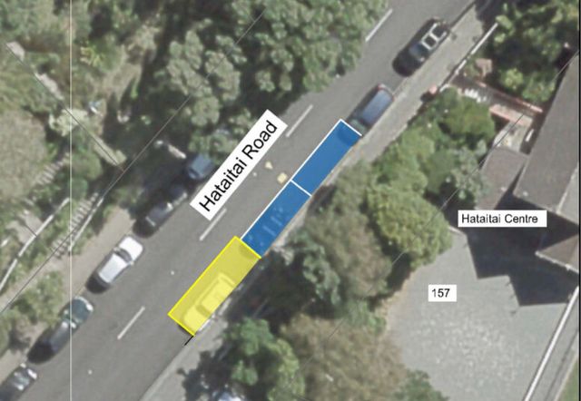
Proposed Parking Restrictions on Hataitai Road
- Hataitai Community Website
- At the request of the Hataitai Community Recreation Trust, WCC are considering some changes to Traffic Restrictions in Hataitai Road.
- Accepted from Hataitai Community website posts by feedreader
- Tagged as:
- hataitai
- parking
Hataitai, Wellington, New Zealand (OpenStreetMap)
-
-
-
Plimmerton Farm: getting greenfields right
- Talk Wellington
- If we’re hellbent on doing more residential development in greenfields, what does “decent” look like in Plimmerton, hilly land near an existing suburb – like most of our region’s greenfields? This post is basically a guide for anyone who cares about Plimmerton, good urban development, or healthy wetlands, streams and coast, but is time-poor and can’t face going through the truckloads of documents they’ve stuck up without any specific meta-guidance (some FAQ are here). Hopefully this will help you pop in a submission! PCC’s “information” pages they suggest you use for submitting. Every one of these is a large PDF document, 90% written in technical language… aargh! The background: what where and how For those who don’t know, Plimmerton Farm’s a big proposed subdivision of hilly farmland draining into the significant Taupō Wetland and to Plimmerton Beach, just over the train line and highway from Plimmerton village (original Ngāti Toa name: Taupō). It’s going through a Streamlined Planning Process, a pre-COVID government scheme for accelerating development. The key step is the requisite change of the land’s zoning in the Porirua District Plan (“rural” zone to “residential” and other “urban” zones) that sets out what kind of stuff can then be built, where. It’s mostly streamlined because there’s just one shot for the public to have input on the plan change. One shot. Why submit? I was born and raised in Plimmerton, live here now, and intend to for the rest of my days. I’d love to see it grow, well. I would love Plimmerton to get more wallets, more hearts and minds, more faces (more diverse ones too!). But not with more traffic, and pointless damage to our environment. Right now, the proposal has some serious flaws which need sorting. I say Sorting because the changes won’t make it crazy innovative, just good enough for a development in the spot it is, being kicked off in 2020. Time matters too: there’a a bunch of good things happening imminently (and some bad Porirua trends that need to be reversed). I cover these in Get it right, below. It’s worth submitting because given the situation, a 1990s-grade development just won’t cut it. So what about Plimmerton Farm needs to change? It boils down to two themes: dial down the driveability and dial up the liveabilitymake Local the logical and easy choice for daily needs I’ll outline what needs to change in each. NOTE: There’s a third – don’t stuff the wetlands and streams. This is really important as Taupō Wetland is regionally significant, and all our streams and harbours have suffered from frankly shameful mismanagement of sediment from earthworks-heavy subdivisions like Aotea and Duck Creek, and from the earthworks-a-rama of Transmission Gully. Friends of Taupo Swamp have an excellent submission guide for you – add in some of their suggested bits to your submission. I: Dial down the driveability, dial up the liveability There aren’t many truly black-and-white things in life, but there’s one for towns: If a street is nice to drive in, it’ll be a crappy place to do anything else in (walk / eat / hang out / have a conversation / play / scoot or cycle / shop / have a pint). If it’s nice to do anything else in, it’ll be a crappy place to drive in. Mostly this is because of the nature of the automobile: big solid things that smash into our soft bodies if someone makes a mistake (75% odds of death if that’s at 50km/hour, 10% odds of death if at 30km/hour) big objects that need lots of space for manoeuvering and especially parking – which offstreet can be crazy expensive and push up the cost of a home, and onstreet hoover up valuable public space. big solid things driven by us real humans (for a while at least) who respond to the environment but also get distracted, and generally aren’t good at wielding these big solid things safely. The transport setup proposed for Plimmerton Farm makes for a much too driveable and poorly liveable place. 1. Narrow down all the roads. The current proposal’s roading setup has roads and streets that are too big, and there’s too much of them. Right sized roads for a liveable community The cross-sections for the roads include on-street parking and really wide lane widths. This is really gobsmacking for a consortium that talked a big talk about good practice. For all the reasons that Low Traffic Neighbourhoods are good, this is bad. (And it’s especially nuts when you realise that the excessively wide “arterial” roads (11 metres!) will need earthworked platforms built for them where they’re drawn running up the sharp ridges and across the tops of gullies. Expensive, damaging for the environment, and … what were they thinking?) So recommended changes: NARROW DOWN THE ROADS. Seriously. Design all the living-area streets and roads, and the centre, to be self-explaining for an operating traffic speed of 30km or less – that’s the speed where mistakes are rarely fatal. What does that look like? The designers will know and if they don’t they should be fired. Narrower crossing distances; chicanes (great way to incorporate green infrastructure and trees and seating!); narrowed sight-lines (trees! sculpture!) so no-one driving feels inclined to zoom. Reduced trafficked lanes (rori iti on the larger roads!), with properly wide and friendly footpaths. Threshold treatments, humps, modal filters, all the things we know very well are the natural ways to slow us down when driving, and make streets nicer for people. The beauty of all this “restriction” on driving is how much it frees us up for making everything else appealing. Streets become hospitable for kids to walk, scoot, bike to school safely, using the road not the footpath. Older people and those with impairments can walk and wheelchair safely. Teens coming home from town of an evening can scoot or bike home, safely. Popping down to the shops or for a coffee or to the train becomes a pleasure to do on foot, or on a scooter or bike. And you’re moving in a legitimate way – seeing and being seen, not stuck off in the bush on a “recreational” track like what they’ve described. The ordinary streets and roads are walkable, bikeable, scootable, mobility-scootable, and perfectly driveable, equally safe and useable in all weathers and anytime of day or night. Used to be a big, fast road. Now, kids bike to school and old people can chill out on it. (Mark Kerrison) (And in case you’re worried about firetrucks / rubbish trucks / buses, recall that on even Wellington City’s far more winding, narrower hilly streets everyone gets their rubbish collected and fires fought just fine. On public transport, smaller buses, like those that community transport operators use, are the way of the future for less densely-populated areas like this). Don’t build the through and loop roads. You don’t need signs like this when the only people who bother to drive in are those who live there, or who are visiting friends, because you just have to drive out again the way you came. When it’s the place you live, you’re invested in not being a dick far more than if you’re just out for a drive – or worse, out for a bit of a boyrace hoon on a massive loop route through a whole place. So just don’t build those big connector roads that enable people to drive easily from one residential area to the next, especially the ones up in the hilltops (section C) that just say “come for a hoon!” Instead, connect the living spaces heavily with bikeable, walkable, scootable, disability-friendly streets and lanes, and as much as possible, only one way in and out for cars from each living area. II: Make local logical and easy Plimmerton is a true village, with a great little centre (including a train station!) but Plimmerton Farm is ultimately a damn big area. The way to go is to enable people to get the basics of life – like school, groceries, a coffee – with a little local trip on foot, bike or scooter – it’s more of a bother to get in the car. Right now though, it needs two changes: 1. Provide for a second centre “Bumping into” spaces are known to be crucial to a feeling of neighbourhood, and in the (initial) absence of third places (worship places, community hall, sports club, cafe/pub, a supermarket is a vital social centre. Yet the north end of Plimmerton Farm is currently a deadzone for anything except residential. What things will probably look like under current layout. Like in Edwards Scissorhands without the interest of a castle. There’s no provision for a place to do your household groceries, so people will drive to Mana New World – more car trips – and less opportunity to bump into people who live nearby. (There’ll be no school in Plimmerton Farm for a while, because Ministry of Education isn’t allowed by the Education Act to build a school somewhere until there’s a certain population density of kids to fill it. A shitty Catch-22 for developments which is hopefully going to be fixed … sometime. Just another reason to make walking, biking and scooting really kid-friendly, as extra dropoff traffic for kids going to St Theresa’s, Plimmerton School, Paremata and Pukerua Bay schools will be a nightmare.) So they should provide for an additional centre in the north, including a groceries place of some kind. 2. Intensify within walking distance of Plimmerton proper. We should intensify properly, with lots of medium and even some high density (6 storeys of nicely laid-out density done well!) in the area that’s within a 5-minute walk of Plimmerton Village. The more people can live and work with access to all its many amenities, and its rail station (10 min to Porirua, 30 min to Wellington), the better. But there’s not enough density provided for there. Plimmerton Railway station: buzzing in 1916 and has only got bigger. (Photo: Pātaka Porirua Museum) So they should add another zone – E – of higher density in that 5-minute walking catchment of Plimmerton Village. What could it look like? A good example is 3333 Main, Vancouver . Submission tips On the site they ask you to fill in a Word or PDF form, saying which specific bit of the gazillion proposals you are talking about and the specific changes you want. This is a BS way to treat the vast majority of people submitting: normal non-professionals, just regular people who care about good development and liveable places. So just don’t worry about that. In those question 6 column boxes just put “Transport” and “Layout”. It’s the professional planners’ job to figure out specifically how to change a planning document. Just be specific enough that they know what you want to see. The text above is worth copying and pasting – it’ll be enough. And don’t forget the Friends of Taupo Swamp and Catchment advice is essential – definitely go read and use. That’s all you really need – just go submit! But if you’re keen to know more reasons why they should be doing this better, here’s some… Get it right, now Once this plan change is through, traditional developers like Gillies like to whack in all the infrastructure – hello, massive earthworks. And yet the place will take decades to fill with actual people – those hearts and minds and wallets. (Note even before COVID, Porirua’s growth rate was 0.1% per year. Yep, one tenth of one percent.) And extra pressure’s on to do this better because all these things are features of the next one to three years: the One Network Road Classification (sets the design specs for roads of different types) is being updated right now to be more people-friendly in the specs for roads in residential and centre areas, so designs like Plimmerton Farm’s will soon be Officially Bad Practice Sales and riding of e-bikes and e-scooters are going through the roof, continuing through and beyond COVID – this shows no signs of slowing, and prices are dropping. E-power flattens the hills of Plimmerton Farm and makes wheely active travel a breeze for the middle-class people who’ll be living here, if the streets and roads are hospitablePlimmerton Railway Station (on the most popular Wellington train line) is being upgraded to be a terminus station – i.e. better servicesThe Wellington Regional Growth Framework is setting a bunch of directions for councils on how to grow well, including well-known but often well-ignored issues like intensifying around public transport hubs Councils will soon be required to do to a bunch of a bunch of international good practice including get rid of many minimum parking requirements (in the news lately), and to upzone (enable intensification) of landuse in the walking catchment of public transport hubs. (5 min walk = approx 400 metres, 10 min = 800m).Bad trends we need to stop: Porirua’s really high car-dependency (we own cars a lot and drive a lot) is continuing, due to car-dependent urban form [PDF]– despite nice words in council’s strategic intentions.People living outside Wellington City are mostly to blame for our region’s 14% increase in emissions from transport in just 10 years. OK go submit now – and share with anyone who you think might care!
- Accepted from Talk Wellington posts by feedreader
- Tagged as:
- paremata
- porirua
- transmission-gully
- sculpture
- government
- parking
- design
- covid-19
- law
- planning
- wellington
- education
- developments
- sport
- buses
- coffee
- zoo
- people
Transmission Gully Motorway, Kenepuru, Porirua, Porirua City, Wellington, 5022, New Zealand (OpenStreetMap)
-
-
-
Submission to Wellington City Council on Parking Policy
- Oriental Bay Residents’ Association
- Submission to WCC on Parking Policy, 6 June 2020Jackie Pope/Ann Mallinson, Co-Presidents, Oriental Bay Residents Association The Oriental Bay Residents Association has considered the Parking Policy 2020 Statement of Proposal, and would comment as follows: We assume we come under the category City Fringe and Inner City Suburbs.
- Accepted from Oriental Bay Residents’ Association 2019 by feedreader
- Tagged as:
- oriental-bay
- fringe-festival
- parking
- wellington
- wellington-city-council
Oriental Bay, Wellington, Wellington City, Wellington, 6011, New Zealand (OpenStreetMap)
-
-
-
WE 💜 PARKING POLICY SUBMISSION GUIDE
- Cycle Aware Wellington (CAW)
- Is parking a problem for you? Long-awaited projects like Newtown Connections have been delayed for this policy, so we’re happy to see it arrive.
- Accepted from Cycle Aware Wellington posts by feedreader
- Tagged as:
- newtown
- parking
Newtown, Wellington, Wellington City, Wellington, New Zealand (OpenStreetMap)
-
-
-
Minutes of the May meeting
- Newtown Residents' Association
- We met again by Zoom on Monday 25th May. After a discussion of local issues and projects we moved to a discussion of the Wellington City Council Draft Parking Policy and Draft Annual Plan. Submissions are due on June 8th for both of these consultations. See the minutes of the meeting here. Newtown Residents’ Association Minutes May 2020Download
- Accepted from NRA news by feedreader
- Tagged as:
- newtown
- issues
- consultation
- parking
- wellington
- zoo
Newtown, Wellington, Wellington City, Wellington, New Zealand (OpenStreetMap)
-
-
-
OBRA presentation to Council, 7 May 2020
- Oriental Bay Residents’ Association
- Re: Pop-up Cycleway and Removal of Angle Parking Thank you for inviting the Oriental Bay Residents Association to present today.
- Accepted from Oriental Bay Residents’ Association 2019 by feedreader
- Tagged as:
- oriental-bay
- island-bay-cycle-way
- parking
Oriental Bay, Wellington, Wellington City, Wellington, 6011, New Zealand (OpenStreetMap)
-
-
-
Minutes of the March 2020 Meeting
- Newtown Residents' Association
- Minutes of the Newtown Residents’ Association meeting 16th March 2020 Present: Rhona Carson (Chair), Steve Cosgrove (Minutes), Leonie Walker, Jane Patterson, Jill Ford, Alison Borbelly, Keith Powell, Tom Law, Don McDonald, Warwick Taylor, Peter Frater, Effie Rankin, Faye Tohbyn, Lyn Morris, Sam Somers, Eileen Brown, Neville Carson, Kevin Lethbridge, Graeme Carroll, Merio Marsters, Marion Leighton. Apologies: Paul Eagle, Dom Shaheen, Steve Dunn, Martin Hanley, Anna Kemble Welch, Jan Gould + Marion Leighton(for lateness)Noted that Paul apologised because MPs have been advised to stay away from community meetings due to Covid-19 risks.. Rhona welcomed everyone to the meeting. Newtown Festival Rhona thanked all the marshalls and other volunteers for helping. The meeting made an enthusiastic vote of thanks and appreciation to the organisers for another very successful Festival.Sadly there was one violent event later in the evening; this seemed to be the result of a personal conflict between two visitors to Newtown. The Police and Community Patrol were involved. Don asked what the noise policy is, as he worries about how loud the Festival is. Tom Law outlined the Council policy. Wellington City Council Consultations Parking Policy. Consultation opened today and will run till April 14th. WCC had a traveling road show on the subject in Newtown Mall this morning. It wasn’t widely advertised and no one at the meeting knew it was going to be there, or attended.Rhona noted that the policy is very high-level at this stage. We recommend that people look at the material on the website. The questions on the web site are quite general so Newtown-specific concerns would need to be added in narrative form.Some general issues were discussed.We will consider different things we can agree on, such as further communication with WCC to develop a Newtown-specific plan, and sensible Residents’ Parking areas and fees. Planning for Growth The WCC Consultation Team were to have a Newtown Festival stall but cancelled because they were not quite ready to go. Next consultation meeting is on 26 March at Prefab – Jane and Rhona interested in going. No one had any further comment: Rhona suggested reading the web page and keeping up-to-date with progress on the development of a proposed spatial plan for the city.District Plan Review – this is beginning at the end of this year or early next. Water Warrick is concerned that water metres are coming back into discussion. This has resulted in some suggesting we ‘need’ water metres to pay for replacement of aged infrastructure.A number of views were expressed regarding the pros and cons of water metering. COVID-19 Eileen Brown is working for the Council of Trade Unions developing plans and consolidating ideas for “managing the risk and flattening the curve”.The current situation was outlined, along with common narratives being used to describe the situation and management options. Eileen described then distributed some information.Marion Leighton (Consultant Physician at Wellington Hospital) arrived during this discussion, having been at a hospital meeting on the same topic. She outlined the hospital’s plans for managing an influx of seriously ill patients and also answered questions. Most important thing is to wash hands frequently and thoroughly, cough and sneeze into your elbow or tissues, don’t touch your face, avoid physical contact with others and self-isolate at the first sign of any symptoms. We are in this for the long-term, so make sure you have a reasonable plan. Emergency Management Discussion Neville Carson outlined his background in Civil Defence (previous name for Emergency Management, and introduced “Wellington Conversations” – facilitated conversations on various topics which have been running in Newtown and elsewhere for several months.Neville is organising a meeting to discuss Emergency Management issues on 31 March, 7:30 to 9:30, at Newtown Hall, using a model based on Wellington Conversations. Circus Performers – Steve informed the meeting that on Wednesday evening (18th Mcaarch) in Carrara Park circus performers will be performing with LED Hula hoops. Meeting ended at 8:58
- Accepted from NRA news by feedreader
- Tagged as:
- newtown
- wellington-city-council
- covid-19
- water
- consultation
- parking
- law
- planning
- wellington
- art
- noise
- hospital
- people
Newtown, Wellington, Wellington City, Wellington, New Zealand (OpenStreetMap)
-
-
-
Circling in a holding pattern- the car parking experience at Wellington airport
- Sarah Free
- On Tuesday, I went to the airport to collect my aunt, visiting from Seattle in the US. I spent a totally frustrating (and dangerous) 10 minutes circling narrow laneways, fruitlessly looking for a car park, witnessing near collisions as cars tried to turn into blind corners, and finally finding a car park at the remotest […]
- Accepted from Sarah Free posts
- Tagged as:
- airport
- parking
Wellington International Airport, Coutts Street, Rongotai, Wellington, Wellington City, Wellington, 6023, New Zealand (OpenStreetMap)
-
-
-
Park: wise
- Jack Yan
- Earlier today, the following press release was issued by my campaign team.
- Accepted from Jack Yan posts
- Tagged as:
- parking
- cuba-street
Wilson, Swan Lane, Te Aro, Wellington, 6011, New Zealand/Aotearoa
-
-
-
The disappearance of nine car parks, and the decline of a heritage shopping precinct
- Wellington Scoop
- n November 2008, road works were started to resurface and widen Riddiford Street in Newtown, from the southern end to the heritage shopping precinct at the intersection of John Street and Adelaide Road. The contractor put up a sign saying the work would take a month. But it took two and a half months, finishing about the middle of February 2009.
- Tagged as:
- cafes
- retail
- parking
- newtown
Newtown, Wellington, Wellington City, Wellington, New Zealand (OpenStreetMap)
-