Government and Porirua
-
-

Wellington councils confirm new water services delivery model
- Upper Hutt City Council
- Five councils covering the Wellington metropolitan area - Hutt City Council, Porirua City Council, Upper Hutt City Council, Wellington City Council and Greater Wellington Regional Council - have all now confirmed they will establish a new, jointly-owned organisation to deliver water services to their communities.
- Accepted from Upper Hutt City news 2021 by feedreader
- Tagged as:
- porirua
- upper-hutt
- wellington-city-council
Upper Hutt, Upper Hutt City, Wellington, 5218, New Zealand (OpenStreetMap)
-
-
-

Whaitua Kāpiti project
- Greater Wellington Regional Council Have Your Say
- Have your say on restoring and protecting Kāpiti's freshwaterTukuna mai he korero mō te whakaora me te whakamaru ō te wai māori ō KāpitiYou can help shape how we care for freshwater in Kāpiti for generations:Complete the 5-minute survey nowEmail us to register your interest in a face-to-face workshop What is a Whaitua?In the Wellington Region we have five ‘whaitua’ - which is a Te Reo Māori word for space, or catchment. In a whaitua, freshwater is connected from the mountains to the sea. Healthy water is central to our lives. Freshwater needs to be protected and restored as healthy waterbodies, and for the communities’ connected with it. Every whaitua is different, so we look at them individually. And now, we turn our attention to Kāpiti. The Whaitua Kāpiti is all the waterbodies from just north of Ōtaki through to Paekākāriki and right up into their headwaters in the Tararua Range.Whaitua Kāpiti CommitteeA team of community members, mana whenua, Kāpiti Coast District Council, and Greater Wellington representatives known as the Whaitua Kāpiti Committee will make recommendations how to restore freshwater in Kāpiti. They will draw on the views and aspirations of the many people who call Kāpiti home.The Committee will describe ways to protect and restore freshwater now and for future generations - such as managing contaminants, water allocation and flows, and setting freshwater aspirations as for the waterbodies throughout Kāpiti.We are interested in freshwater. This means the water in our rivers, streams, lakes, wetlands, springs and underground in aquifers and their flow on effects to estuaries and the coast. Your aspirationsWe're seeking your freshwater aspirations because everyone has a unique perspective on how we protect our fresh water. We can't do it without you.This is your opportunity to provide your views into what needs to be done to restore healthy freshwater in Kāpiti.You can have a say on Kāpiti's fresh water in two main ways.E rua ngā kōwhiringa kia tukuna mai ō whakaaro mō te wai māori ō KapitiFill in our 5-minute survey. Don't leave it too late - the survey will close on 22 November 2022.Come along to a face-to-face workshop.Our workshopJoin us in us in Kāpiti in early November for a community workshop. You’ll meet with others to share ideas and provide deeper input into restoring and protecting wai ora, freshwater. We want to ensure that workshops include the values, experiences, and views of our diverse Kāpiti communities. Anyone who would like to contribute to the kōrero is welcome to come along. We particularly welcome Māori, Pasifika, ethnic communities, rangatahi, disabled, rainbow and people living in rural communities.Our workshop will be accessible and inclusive. Please let us know how we can support you in attending.If you’d like to attend, send us an email and we’ll get back to you.What will happen with the information you share? Ka ahatia ngā korero kua tohaina e koe?Your feedback will be put together in an independent report for the Whaitua Kāpiti Committee. This report will help the Whaitua Committee develop the Whaitua Implementation Programme to suit Kāpiti's needs.Keeping you informed about the findingsKia whakamohio ai koe ki ngā otinga ō tēnei mahiWhen the findings are ready to be released, we will send you a link to the report and provide it on the Greater Wellington website. You can also join our mailing list so we can keep you up to date on restoring and protecting Kāpiti's freshwater and opportunities to have a further say.Want to know more about the Whaitua process? Kei te hiahia koe te mohio mō te tikanga Whaitua?Our website has more detail about the Whaitua process. You will also find completed Implementation Programmes for Te Whanganui-a-Tara Whaitua, Ruamāhanga Whaitua, and Te Awarua-o-Porirua Whaitua.Any questions?He pātai?Email us at whaitua@gw.govt.nz to ask questions, want to speak to someone, or to sign up to our mailing list.
- Accepted from Have your say projects by tonytw1
- Tagged as:
- kapiti
- porirua
Porirua, Wellington Region, New Zealand (OpenStreetMap)
-
-
-
Porirua City Council puts through new process to tackle Spicer Landfill odour reports
- Greater Wellington Regional Council
- Accepted from GW news 2022 by feedreader
- Tagged as:
- spicer-landfill
Spicers Landfill, Tawa, Wellington City, Wellington, New Zealand (OpenStreetMap)
-
-
-
Porirua City Council put in place new process to tackle Spicer Landfill odour reports
- Greater Wellington Regional Council
- Porirua City Council is putting in a range of new efforts to help make community members’ odour reports for Spicer Landfill easier and provide greater data for the city council. From 8am Tuesday 27 September, Spicer Landfill odour issues should be reported directly to Porirua City Council’s contact centre on 04 237 5089, including after hours. David Down, Porirua City Council Manager Water and Waste, said community reports of odour would be shared with Greater Wellington the same day. “Porirua City Council will be taking the calls and collecting information. We are also looking to engage independent personnel to make odour observations in the community when complaints are received after hours, to help get good data on when and where these occur.
- Accepted from GW news 2022 by feedreader
- Tagged as:
- tawa
- spicer-landfill
Spicers Landfill, Tawa, Wellington City, Wellington, New Zealand (OpenStreetMap)
-
-
-
Surprising variety of life headlines new report on Porirua Harbour health
- Greater Wellington Regional Council
- Accepted from GW news 2022 by feedreader
- Tagged as:
- porirua
Porirua, Wellington Region, New Zealand (OpenStreetMap)
-
-
-
Willowbank Quarry - Publicly Notified Consent
- Greater Wellington Regional Council Have Your Say
- This application has been notified concurrently with Porirua City Council. This application seeks resource consents from Wellington Regional (Greater Wellingon) for the continued operation and long-term expansion of Willowbank Quarry (the Quarry), located on Willowbank Farm, in Judgeford, Porirua.
- Accepted from Have your say projects by tonytw1
- Tagged as:
- porirua
- consultation
Willowbank Quarry, Porirua, Porirua City, Wellington, New Zealand (OpenStreetMap)
-
-
-
Notified Consent Application – Silverstream Pipeline Bridge
- Greater Wellington Regional Council Have Your Say
- OverviewThe Silverstream Pipeline Replacement project (the Project) proposes to replace an existing section of the ‘Te Mārua to Karori’ pipeline (known as the Kaitoke Main) at Silverstream which, under normal conditions, supplies 100% of Porirua City’s and 40% of Wellington City’s potable water supply.
- Accepted from Have your say projects by tonytw1
- Tagged as:
- karori
- porirua
- silverstream
Silverstream, Upper Hutt, Upper Hutt City, Wellington, 5019, New Zealand (OpenStreetMap)
-
-
-
Local leaders welcome 3 Waters decision
- Greater Wellington Regional Council
- Source: Porirua City Council Porirua’s Mayor and the Greater Wellington Regional Council Chair welcome the Government decision on an "all in" approach to 3 Waters reforms as a positive step towards improved and consistent delivery of water services across New Zealand.
- Accepted from GW media releases 2019 by feedreader
- Tagged as:
- porirua
Porirua, Wellington Region, New Zealand (OpenStreetMap)
-
-
-
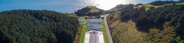
Porirua Wastewater Treatment Plant notified consent application
- Greater Wellington Regional Council Have Your Say
- Notification of application for resource consent WGN200229 under section 95A of the Resource Management Act 1991Applicant:Porirua City CouncilAddress for service:Wellington Water LimitedPrivate Bag 39804Wellington Mail Centre 5405Attn: Richard Peterson, richard.
- Accepted from Have your say projects by tonytw1
- Tagged as:
- porirua
Porirua, Wellington Region, New Zealand (OpenStreetMap)
-
-
-
Surveying mud – key to monitoring the health of Te-Awarua-o-Porirua Harbour
- Greater Wellington Regional Council
- Last month Greater Wellington conducted the sixth underwater survey in Te Awarua-o-Porirua Harbour as a part of a programme to assess the environmental health of the highly valued Onepoto and Pāuatahanui estuaries.
- Accepted from GW media releases 2019 by feedreader
- Tagged as:
- porirua
Porirua, Wellington Region, New Zealand (OpenStreetMap)
-
-
-
Plimmerton Farm: getting greenfields right
- Talk Wellington
- If we’re hellbent on doing more residential development in greenfields, what does “decent” look like in Plimmerton, hilly land near an existing suburb – like most of our region’s greenfields? This post is basically a guide for anyone who cares about Plimmerton, good urban development, or healthy wetlands, streams and coast, but is time-poor and can’t face going through the truckloads of documents they’ve stuck up without any specific meta-guidance (some FAQ are here). Hopefully this will help you pop in a submission! PCC’s “information” pages they suggest you use for submitting. Every one of these is a large PDF document, 90% written in technical language… aargh! The background: what where and how For those who don’t know, Plimmerton Farm’s a big proposed subdivision of hilly farmland draining into the significant Taupō Wetland and to Plimmerton Beach, just over the train line and highway from Plimmerton village (original Ngāti Toa name: Taupō). It’s going through a Streamlined Planning Process, a pre-COVID government scheme for accelerating development. The key step is the requisite change of the land’s zoning in the Porirua District Plan (“rural” zone to “residential” and other “urban” zones) that sets out what kind of stuff can then be built, where. It’s mostly streamlined because there’s just one shot for the public to have input on the plan change. One shot. Why submit? I was born and raised in Plimmerton, live here now, and intend to for the rest of my days. I’d love to see it grow, well. I would love Plimmerton to get more wallets, more hearts and minds, more faces (more diverse ones too!). But not with more traffic, and pointless damage to our environment. Right now, the proposal has some serious flaws which need sorting. I say Sorting because the changes won’t make it crazy innovative, just good enough for a development in the spot it is, being kicked off in 2020. Time matters too: there’a a bunch of good things happening imminently (and some bad Porirua trends that need to be reversed). I cover these in Get it right, below. It’s worth submitting because given the situation, a 1990s-grade development just won’t cut it. So what about Plimmerton Farm needs to change? It boils down to two themes: dial down the driveability and dial up the liveabilitymake Local the logical and easy choice for daily needs I’ll outline what needs to change in each. NOTE: There’s a third – don’t stuff the wetlands and streams. This is really important as Taupō Wetland is regionally significant, and all our streams and harbours have suffered from frankly shameful mismanagement of sediment from earthworks-heavy subdivisions like Aotea and Duck Creek, and from the earthworks-a-rama of Transmission Gully. Friends of Taupo Swamp have an excellent submission guide for you – add in some of their suggested bits to your submission. I: Dial down the driveability, dial up the liveability There aren’t many truly black-and-white things in life, but there’s one for towns: If a street is nice to drive in, it’ll be a crappy place to do anything else in (walk / eat / hang out / have a conversation / play / scoot or cycle / shop / have a pint). If it’s nice to do anything else in, it’ll be a crappy place to drive in. Mostly this is because of the nature of the automobile: big solid things that smash into our soft bodies if someone makes a mistake (75% odds of death if that’s at 50km/hour, 10% odds of death if at 30km/hour) big objects that need lots of space for manoeuvering and especially parking – which offstreet can be crazy expensive and push up the cost of a home, and onstreet hoover up valuable public space. big solid things driven by us real humans (for a while at least) who respond to the environment but also get distracted, and generally aren’t good at wielding these big solid things safely. The transport setup proposed for Plimmerton Farm makes for a much too driveable and poorly liveable place. 1. Narrow down all the roads. The current proposal’s roading setup has roads and streets that are too big, and there’s too much of them. Right sized roads for a liveable community The cross-sections for the roads include on-street parking and really wide lane widths. This is really gobsmacking for a consortium that talked a big talk about good practice. For all the reasons that Low Traffic Neighbourhoods are good, this is bad. (And it’s especially nuts when you realise that the excessively wide “arterial” roads (11 metres!) will need earthworked platforms built for them where they’re drawn running up the sharp ridges and across the tops of gullies. Expensive, damaging for the environment, and … what were they thinking?) So recommended changes: NARROW DOWN THE ROADS. Seriously. Design all the living-area streets and roads, and the centre, to be self-explaining for an operating traffic speed of 30km or less – that’s the speed where mistakes are rarely fatal. What does that look like? The designers will know and if they don’t they should be fired. Narrower crossing distances; chicanes (great way to incorporate green infrastructure and trees and seating!); narrowed sight-lines (trees! sculpture!) so no-one driving feels inclined to zoom. Reduced trafficked lanes (rori iti on the larger roads!), with properly wide and friendly footpaths. Threshold treatments, humps, modal filters, all the things we know very well are the natural ways to slow us down when driving, and make streets nicer for people. The beauty of all this “restriction” on driving is how much it frees us up for making everything else appealing. Streets become hospitable for kids to walk, scoot, bike to school safely, using the road not the footpath. Older people and those with impairments can walk and wheelchair safely. Teens coming home from town of an evening can scoot or bike home, safely. Popping down to the shops or for a coffee or to the train becomes a pleasure to do on foot, or on a scooter or bike. And you’re moving in a legitimate way – seeing and being seen, not stuck off in the bush on a “recreational” track like what they’ve described. The ordinary streets and roads are walkable, bikeable, scootable, mobility-scootable, and perfectly driveable, equally safe and useable in all weathers and anytime of day or night. Used to be a big, fast road. Now, kids bike to school and old people can chill out on it. (Mark Kerrison) (And in case you’re worried about firetrucks / rubbish trucks / buses, recall that on even Wellington City’s far more winding, narrower hilly streets everyone gets their rubbish collected and fires fought just fine. On public transport, smaller buses, like those that community transport operators use, are the way of the future for less densely-populated areas like this). Don’t build the through and loop roads. You don’t need signs like this when the only people who bother to drive in are those who live there, or who are visiting friends, because you just have to drive out again the way you came. When it’s the place you live, you’re invested in not being a dick far more than if you’re just out for a drive – or worse, out for a bit of a boyrace hoon on a massive loop route through a whole place. So just don’t build those big connector roads that enable people to drive easily from one residential area to the next, especially the ones up in the hilltops (section C) that just say “come for a hoon!” Instead, connect the living spaces heavily with bikeable, walkable, scootable, disability-friendly streets and lanes, and as much as possible, only one way in and out for cars from each living area. II: Make local logical and easy Plimmerton is a true village, with a great little centre (including a train station!) but Plimmerton Farm is ultimately a damn big area. The way to go is to enable people to get the basics of life – like school, groceries, a coffee – with a little local trip on foot, bike or scooter – it’s more of a bother to get in the car. Right now though, it needs two changes: 1. Provide for a second centre “Bumping into” spaces are known to be crucial to a feeling of neighbourhood, and in the (initial) absence of third places (worship places, community hall, sports club, cafe/pub, a supermarket is a vital social centre. Yet the north end of Plimmerton Farm is currently a deadzone for anything except residential. What things will probably look like under current layout. Like in Edwards Scissorhands without the interest of a castle. There’s no provision for a place to do your household groceries, so people will drive to Mana New World – more car trips – and less opportunity to bump into people who live nearby. (There’ll be no school in Plimmerton Farm for a while, because Ministry of Education isn’t allowed by the Education Act to build a school somewhere until there’s a certain population density of kids to fill it. A shitty Catch-22 for developments which is hopefully going to be fixed … sometime. Just another reason to make walking, biking and scooting really kid-friendly, as extra dropoff traffic for kids going to St Theresa’s, Plimmerton School, Paremata and Pukerua Bay schools will be a nightmare.) So they should provide for an additional centre in the north, including a groceries place of some kind. 2. Intensify within walking distance of Plimmerton proper. We should intensify properly, with lots of medium and even some high density (6 storeys of nicely laid-out density done well!) in the area that’s within a 5-minute walk of Plimmerton Village. The more people can live and work with access to all its many amenities, and its rail station (10 min to Porirua, 30 min to Wellington), the better. But there’s not enough density provided for there. Plimmerton Railway station: buzzing in 1916 and has only got bigger. (Photo: Pātaka Porirua Museum) So they should add another zone – E – of higher density in that 5-minute walking catchment of Plimmerton Village. What could it look like? A good example is 3333 Main, Vancouver . Submission tips On the site they ask you to fill in a Word or PDF form, saying which specific bit of the gazillion proposals you are talking about and the specific changes you want. This is a BS way to treat the vast majority of people submitting: normal non-professionals, just regular people who care about good development and liveable places. So just don’t worry about that. In those question 6 column boxes just put “Transport” and “Layout”. It’s the professional planners’ job to figure out specifically how to change a planning document. Just be specific enough that they know what you want to see. The text above is worth copying and pasting – it’ll be enough. And don’t forget the Friends of Taupo Swamp and Catchment advice is essential – definitely go read and use. That’s all you really need – just go submit! But if you’re keen to know more reasons why they should be doing this better, here’s some… Get it right, now Once this plan change is through, traditional developers like Gillies like to whack in all the infrastructure – hello, massive earthworks. And yet the place will take decades to fill with actual people – those hearts and minds and wallets. (Note even before COVID, Porirua’s growth rate was 0.1% per year. Yep, one tenth of one percent.) And extra pressure’s on to do this better because all these things are features of the next one to three years: the One Network Road Classification (sets the design specs for roads of different types) is being updated right now to be more people-friendly in the specs for roads in residential and centre areas, so designs like Plimmerton Farm’s will soon be Officially Bad Practice Sales and riding of e-bikes and e-scooters are going through the roof, continuing through and beyond COVID – this shows no signs of slowing, and prices are dropping. E-power flattens the hills of Plimmerton Farm and makes wheely active travel a breeze for the middle-class people who’ll be living here, if the streets and roads are hospitablePlimmerton Railway Station (on the most popular Wellington train line) is being upgraded to be a terminus station – i.e. better servicesThe Wellington Regional Growth Framework is setting a bunch of directions for councils on how to grow well, including well-known but often well-ignored issues like intensifying around public transport hubs Councils will soon be required to do to a bunch of a bunch of international good practice including get rid of many minimum parking requirements (in the news lately), and to upzone (enable intensification) of landuse in the walking catchment of public transport hubs. (5 min walk = approx 400 metres, 10 min = 800m).Bad trends we need to stop: Porirua’s really high car-dependency (we own cars a lot and drive a lot) is continuing, due to car-dependent urban form [PDF]– despite nice words in council’s strategic intentions.People living outside Wellington City are mostly to blame for our region’s 14% increase in emissions from transport in just 10 years. OK go submit now – and share with anyone who you think might care!
- Accepted from Talk Wellington posts by feedreader
- Tagged as:
- paremata
- porirua
- transmission-gully
- sculpture
- government
- parking
- design
- covid-19
- law
- planning
- wellington
- education
- developments
- sport
- buses
- coffee
- zoo
- people
Transmission Gully Motorway, Kenepuru, Porirua, Porirua City, Wellington, 5022, New Zealand (OpenStreetMap)
-
-
-
Roving crew to help fix water quality issues
- Greater Wellington Regional Council
- Porirua City Council is the first council in the Wellington region to implement a Wellington Water proposal to establish a roving crew, taking a proactive approach to the health of local waterways and timely action when water quality issues arise.
- Accepted from GW media releases 2019 by feedreader
- Tagged as:
- porirua
Porirua, Wellington Region, New Zealand (OpenStreetMap)
-
-
-
Greater Wellington shares final bus review plans
- Greater Wellington Regional Council
- Greater Wellington Regional Council detailed the final part of its bus network review for Kāpiti Coast, Wairarapa, Porirua and the Hutt Valley at today’s Transport Committee meeting.
- Accepted from GW media releases 2019 by feedreader
- Tagged as:
- hutt-valley
- porirua
- wairarapa
Porirua, Wellington Region, New Zealand (OpenStreetMap)
-
-
-
Environment fund pays off
- Greater Wellington Regional Council
- Eight local Enviroschools working to restore wetland areas and create lizard gardens showcased their work at an ‘Enviroschools Porirua Living Landscapes Student Celebration’ on Tuesday, September 24.
- Accepted from GW media releases 2019 by feedreader
- Tagged as:
- porirua
Porirua, Wellington Region, New Zealand (OpenStreetMap)
-
-
-
Fine for illegal pollution discharge
- Greater Wellington Regional Council
- Wellington Water has been convicted and fined $67,500 for an illegal discharge of sewage sludge from the Porirua City Wastewater Treatment Plant.
- Accepted from GW media releases 2019 by feedreader
- Tagged as:
- porirua
Porirua, Wellington Region, New Zealand (OpenStreetMap)
-
-
-
Harbour sediment rates too high for healthy habitats
- Greater Wellington Regional Council
- A recent survey of Te Awarua-o-Porirua Harbour shows sedimentation rates have more than doubled in the last five years, undermining animal and plant habitats and the healthy functioning of this estuary.
- Accepted from GW media releases 2019 by feedreader
- Tagged as:
- porirua
Porirua, Wellington Region, New Zealand (OpenStreetMap)
-
-
-
Planting empowers potential for Porirua waterway
- Greater Wellington Regional Council
- Students from Natone, Porirua and Windley schools got digging this week, planting over 600 trees at Bothamley Park thanks to a collaboration between Greater Wellington Regional Council, Sustainable Coastlines and Porirua City Council.
- Accepted from GW media releases 2019 by feedreader
- Tagged as:
- porirua
Porirua, Wellington Region, New Zealand (OpenStreetMap)
-
-
-
Porirua Harbour Restoration fund 2016 open
- Greater Wellington Regional Council
- Applications for Greater Wellington Regional Council’s annual fund for community groups focussed on environmental restoration around Te Awarua-o-Porirua Harbour catchment opens tomorrow, Thursday 1 September 2016.
- Accepted from GW Feed
- Tagged as:
- porirua
Porirua, Wellington Region, New Zealand (OpenStreetMap)
-
-
-
Porirua water quality report “variable”
- Greater Wellington Regional Council
- Many places in Porirua are good for swimming but a few spots are not so great, especially after rain, a new Recreational Water Quality report card shows.
- Accepted from GW Feed
- Tagged as:
- porirua
Porirua, Wellington Region, New Zealand (OpenStreetMap)
-
-
-
Porirua residents invited to 'drop in' and chat about Wellington
- Greater Wellington Regional Council
- Porirua residents are being invited to drop in to the Porirua Club on Tuesday 26 April and have a chat about Wellington.
- Accepted from GW Feed
- Tagged as:
- porirua
Porirua, Wellington Region, New Zealand (OpenStreetMap)
-
-
-
Porirua commuters encouraged to explore Park & Ride alternatives
- Greater Wellington Regional Council
- While you normally can’t have too much of a good thing, it’s a different story at the increasingly popular Porirua Station Park and Ride - and commuters who can’t get a park need to consider other options such as taking the bus, carpooling or parking at other stations to help ease the congestion.
- Accepted from GW Feed
- Tagged as:
- porirua
Porirua, Wellington Region, New Zealand (OpenStreetMap)
-
-
-
What does the Porirua community believe is important about their water?
- Greater Wellington Regional Council
- Te Awarua-o-Porirua Whaitua Committee wants Porirua people to tell them what's important about their water.
- Accepted from GW Feed
- Tagged as:
- porirua
Porirua, Wellington Region, New Zealand (OpenStreetMap)
-
-
-
New regional fund aims to restore our natural environment
- Greater Wellington Regional Council
- Five lucky community groups are receiving funding from Greater Wellington Regional Council to restore native plants to areas around the Te Awarua-o-Porirua Harbour catchment.
- Accepted from GW Feed
- Tagged as:
- porirua
Porirua, Wellington Region, New Zealand (OpenStreetMap)
-
-
-
Council prioritises Chinese Garden and Cycleway over Hospital Water Supply
- WCC Watch
- Capital and Coast DHB Board Member and Porirua Mayor, Nick Leggett and Southern Ward Councillor, Paul Eagle, have highlighted a bizarre decision by Council to refuse to fund the emergency water reservoir that serves the Hospital.
- Accepted from WCC Watch feed
- Tagged as:
- island-bay-cycle-way
- porirua
Porirua, Wellington Region, New Zealand (OpenStreetMap)
-
-
-
Supporting restoration in the Porirua Harbour Catchment
- Greater Wellington Regional Council
- Greater Wellington Regional Council has launched a new contestable fund to support community groups in their efforts to restore native plants to public areas around the beautiful Porirua Harbour catchment.
- Accepted from GW Feed
- Tagged as:
- porirua
Porirua, Wellington Region, New Zealand (OpenStreetMap)
-
-
-
Porirua Stream Clean-up finished well ahead of schedule
- Greater Wellington Regional Council
- A huge clean-up operation in the Porirua Stream finished last week, well ahead of schedule.
- Accepted from GW Feed
- Tagged as:
- porirua
Porirua, Wellington Region, New Zealand (OpenStreetMap)
-
-
-
Understanding a valuable resource
- Greater Wellington Regional Council
- The community is encouraged to attend a meeting of Te Awarua-o-Porirua Whaitua Committee on Monday night to learn about the state of natural water in the catchment.
- Accepted from GW Feed
- Tagged as:
- porirua
Porirua, Wellington Region, New Zealand (OpenStreetMap)
-
-
-
Flood Clean-up Continues for Porirua Stream
- Greater Wellington Regional Council
- Work to alleviate storm water outlet blockages, localised flooding and management of a huge volume of unwanted gravel in the Porirua Stream will begin next week.
- Accepted from GW Feed
- Tagged as:
- porirua
Porirua, Wellington Region, New Zealand (OpenStreetMap)
-
-
-
Te Awarua-o-Porirua Whaitua Committee Chair Appointed
- Greater Wellington Regional Council
- Community conservationist and ecological engineer Stu Farrant has been elected to chair the recently formed Te Awarua-o-Porirua Whaitua Committee.
- Accepted from GW Feed
- Tagged as:
- porirua
Porirua, Wellington Region, New Zealand (OpenStreetMap)
-
-
-
Grab some gravel
- Greater Wellington Regional Council
- Take some hard fill for your home and garden projects this weekend - and help protect your community from flooding.
- Accepted from GW Feed
- Tagged as:
- kilbirnie
- roseneath
- stokes-valley
- aro-valley
- wilton
- miramar
- tawa
- worser-bay
- ngaio
- makara
- begonia-house
- waterfront
- island-bay
- thorndon
- hutt-valley
- wainuiomata
- newlands
- mount-victoria
- kelburn
- seatoun
- paraparaumu
- johnsonville
- hataitai
- wairarapa
- lyall-bay
- eastbourne
- paremata
- wadestown
- karori
- oriental-bay
- mount-cook
- civic-square
- porirua
- cuba-street
- brooklyn
- northland
- titahi-bay
- khandallah
- newtown
- berhampore
Eastbourne, Lower Hutt, Lower Hutt City, Wellington, New Zealand/Aotearoa (OpenStreetMap)
-